ppl mad at me @blackgirlscode @nasa-jpl @whitehouse
#
#
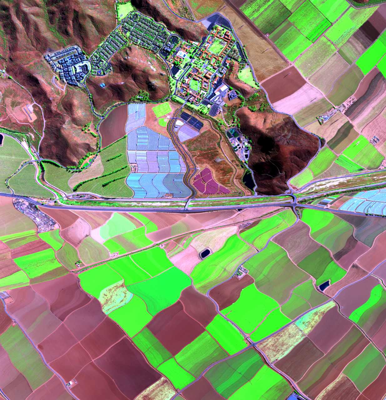
Clementine
Clementine was a joint NASA/DoD mission to the Moon, 1991-1994. The Geosciences Node archives the following Clementine data:
Clementine - NASA Misson LunaData Explorer
RelatedTweet LunAr Map !
RelatedTweet - Mission Voyager @nasa
Los Angeles Winter Fire Support
Related
El NinO
RelatedTweet
LAADS
Level-1 and Atmosphere Archive & Distribution system
Very similar to LANCE_FiRMS but different data AtmosphereFocused - View Data User Guide
https://x.com/thakasartu/status/1895542988853625306/photo/1
2017 NAS User Survey Results - NASAJPL
EARTH SCIENCE RESEARCH PROGRAM
EARTH SCIENCE RESEARCH OVERVIEW ROSES-2024
APPENDIX A. WorkEffortTemplate
Ground Data Systems and Mission Operations
Ground & Flight Data Systems Group
Overview
The Ground & Flight Data Systems (GFDS) Group creates systems to facilitate transmission and processing of data between spacecraft, rovers, satellites, ground control, and distributed mission teams. Data ranges from communications, telemetry, and Integrated Systems Health Management (ISHM) data, to planetary, astrophysical, medical, and biological science research data and analytics. Ground processing of data is accomplished by science pipeline data systems, which transform raw, uncorrected, uncalibrated data into usable products for the science community. ReadMore - NASA 2022 Ground Data Systems Chapter
READMORE - SWOT
Documentation : MULTI-MISSION GROUND DATA SYSTEMS: BREAKTHROUGHS AND CHALLENGES - M. Tankenson, J. Cruz NASA JPL Data Center Consolidation, Ph. III
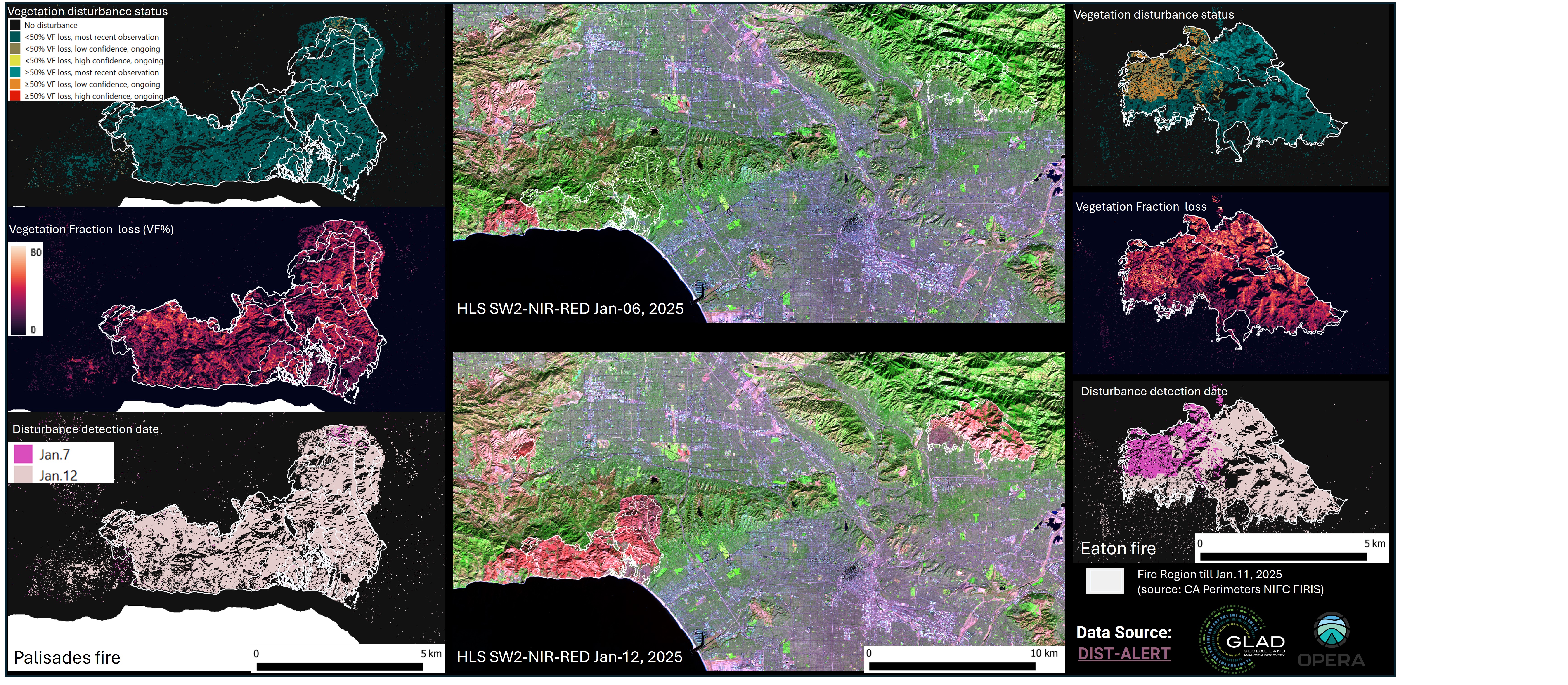
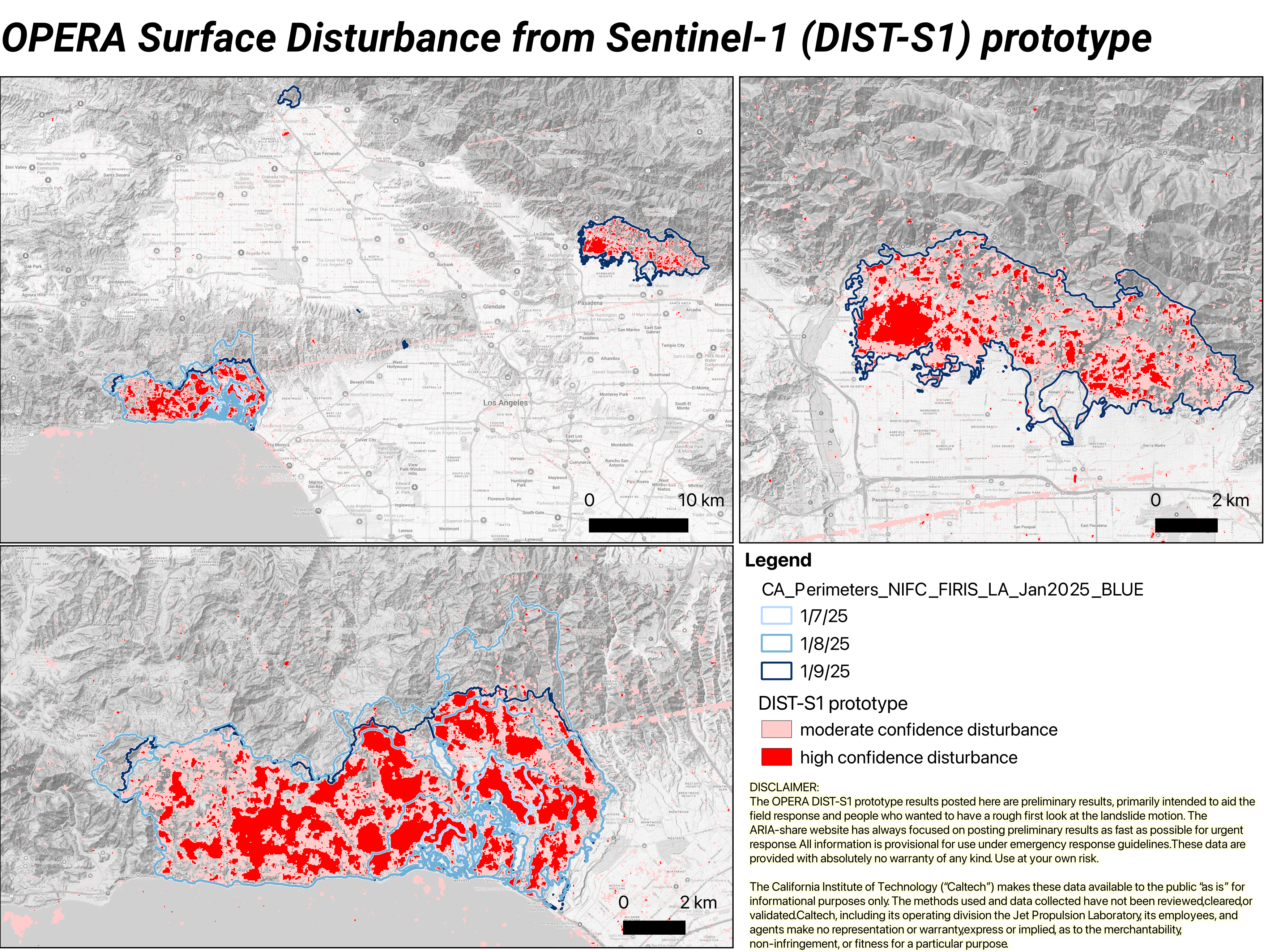
ARIA/OPERA Surface Disturbance from Sentinel-1 (DIST-S1) prototype
Researchers working with the Advanced Rapid Imaging and Analysis (ARIA) and Observational Products for End-Users from Remote Sensing Analysis (OPERA) teams at NASA’s Jet Propulsion Laboratory, Pasadena, California , created the OPERA Surface Disturbance Alert from Sentinel-1 (DIST-S1-ALERT) prototype product suite to create maps of surface disturbance due to ongoing wildfires in Los Angeles County in January 2025. The land Surface Disturbance product (DIST) maps disturbance detected when there is a change outside a historical norm using optical or SAR imagery. DIST Product Suite DAAC - OPERA_L3_DIST-ALERT-HLS_PROVISIONAL_V0 v000
NASA’s Jet Propulsion Laboratory unscathed by Eaton fire, but not its workforce - LATiMES <~ @datadesk
FoR LATER ARiA
Data Alerts and Outages
NEAR SPACE NETWORK (NSN)
Monitoring NSN
NISAR Sample Data Product Suite
DAAC LiST
ASDC | Atmospheric Science Data Center
atmospheric science data products and services TOOLS
Alaska Satellite Facility
Training + USERGuides
Oak Ridge
NAtional Laboratory
Nasa Projects
Oak Ridge National Laboratory delivers scientific discoveries and technical breakthroughs needed to realize solutions in energy and national security and provide economic benefit to the nation. ReadMore DataManagement
Imagery
RepKArenBassDeliverables
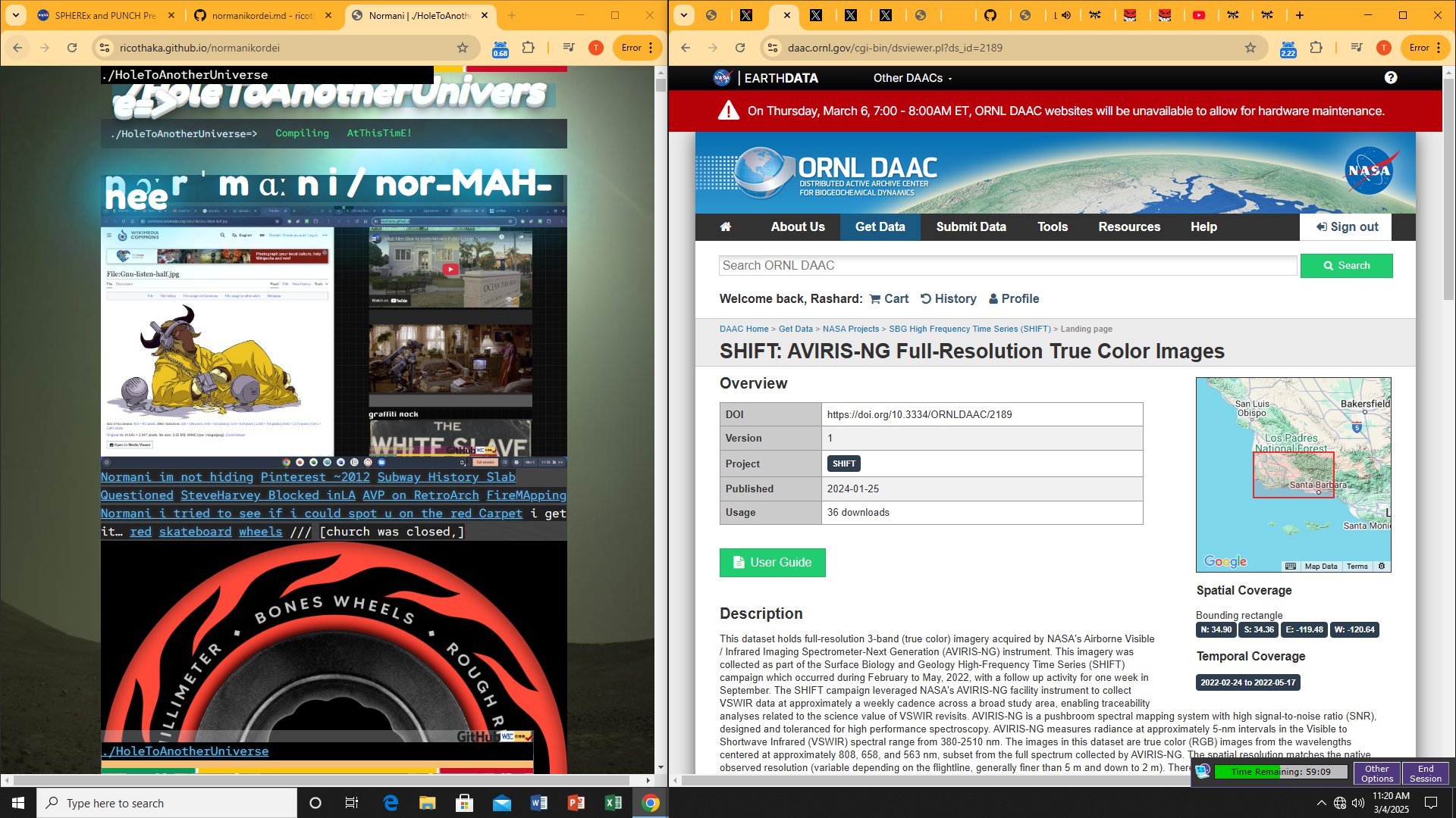
Mayor Bass/ Governor Newsom, i found older Aviris Scans of Santa Barbera Published - 2024-01-25 This imagery was collected as part of the Surface Biology and Geology High-Frequency Time Series (SHIFT ) campaign which occurred during February to May, 2022, with a follow up activity for one week in September. RelatedTwT SHIFT: AVIRIS-NG Full-Resolution True Color Images MissionDocs
The Bay Foundation RelatedTweet
Data Use and Citation
Brodrick, P.G., R. Pavlick, M. Bernas, J.W. Chapman, R. Eckert, M. Helmlinger, M. Hess-Flores, L.M. Rios, F.D. Schneider, M.M. Smyth, M. Eastwood, R.O. Green, D.R. Thompson, K.D. Chadwick, and D.S. Schimel. 2023. SHIFT: AVIRIS-NG Full-Resolution True Color Images. ORNL DAAC, Oak Ridge, Tennessee, USA. https://doi.org/10.3334/ORNLDAAC/2189
Commit 4a8760a
Selected Palisades Files to sample
AVIRIS-3 L1B Calibrated Radiance, Facility Instrument Collection related
AvirisTweet Holly Bender AvirisDataPortal AVIRIS-Classic Data Portal CUBE
SoilMoistureVisualiser Asking Mayor Bass to examine what we offer at JPL Aviris FlightLines
RelatedTweet nassaJPLfire
NASA | LANCE | FIRMS - NASA Firms
FLiGHTLiNES.CSV Coast
RelatedTweet RELATEDTWEET
RelatedTweet
S͟q̲uare p̲u̲sher - Fe͟ed Me͟ Wei͟rd Thi͟ngs (Full Album)
Open Metro
Providing Active Fire Data for Near-Real Time Monitoring and Applications
The Fire Information for Resource Management System (FIRMS) distributes Near Real-Time (NRT) active fire data from the Moderate Resolution Imaging Spectroradiometer (MODIS) aboard the Aqua and Terra satellites, and the Visible Infrared Imaging Radiometer Suite (VIIRS) aboard S-NPP, NOAA 20 and NOAA 21 (formally known as JPSS-1 and JPSS-2). Globally these data are available within 3 hours of satellite observation, but for the US and Canada active fire detections are available in real-time.
Nasa Lance Firms Fire Information Management Console (ClimateTooL)
Making Git Good
https://landsatlook.USGS climatetool USGS LandsatLook Viewer
https://x.com/BubbleGumPop626/status/1810049106016112786
Panoply netCDF, HDF and GRIB Data Viewer
panoply \PAN-uh-plee\, noun: 1. A splendid or impressive array. …
Panoply plots geo-referenced and other arrays from netCDF , HDF , GRIB , and other datasets.
Panoply is a cross-platform application that runs on Macintosh, Windows, Linux and other desktop computers. Panoply requires that your computer has have had a compatible Java 11 (or later version) JRE or JDK installed.
A quick tour of netCDF data - Argis
GOES-VieWR-WEATHER
AT&T Archives: Telstar!
Telstar 1
AT&T Archives: A Modern Aladdin’s Lamp, about vacuum tubes,1940
</ARTICLE>
</ARTICLE>
## OCEAN
[Distributed Oceanographic Matchup Service (DOMS)](https://doms.jpl.nasa.gov/)
[Locust Watch](https://www.fao.org/locust-watch/en)
[Scientific Visualization Studio](https://svs.gsfc.nasa.gov/)
## webtools
[DSCOVR: EPIC](https://epic.gsfc.nasa.gov/)
[Earth](https://earthobservatory.nasa.gov/)
## NASA DsN
#theSUN() resources
[Johs Hopkins APL](https://x.com/JHUAPL)
[the STEREO website](https://stereo.gsfc.nasa.gov/)
[SDOlab](https://sdo.gsfc.nasa.gov/)
[TheSun](https://stereo.gsfc.nasa.gov/img/3dimages/movies/Jul9_171A_motion.mp4)
[DEEP SPACE NETWORK](https://eyes.nasa.gov/apps/dsn-now/dsn.html)

[waybackmachine](https://web.archive.org/)
The real time status of communications with our deep space explorers
[GEOCiTiS](https://www.oocities.org/index.html?cx=partner-pub-8125734003905602%3A8492870096&cof=FORID%3A10&ie=UTF-8&q=sb202us&sa=Search&siteurl=www.oocities.org%2F&ref=www.google.com%2F&ss=2319j1791797j7#gsc.tab=0)
# EarthData Search
[EarthData Search](https://search.earthdata.nasa.gov/search)
[DAR Tool @usgs](https://dartool.cr.usgs.gov/Main.php)
# [object-fit](https://developer.mozilla.org/en-US/docs/Web/CSS/object-fit) The object-fit CSS property sets how the content of a replaced element, such as an , should be resized to fit its container. [@mozilla MDN](https://developer.mozilla.org/en-US/docs/Web/CSS/object-fit)
## Design for different form factors
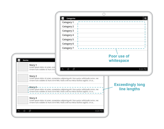 The design of your app’s UI isn't tied to a particular device form factor. Android applications need to adapt to a number of different types of devices, from 4-inch handsets to 50-inch TVs to ChromeOS devices with resizable windows. [readmore - developer.android.com](https://developer.android.com/guide/navigation/responsive/form-factors)
[FLexBox - flex-direction](https://developer.mozilla.org/en-US/docs/Web/CSS/flex-direction) , Im working on the main container for [HoletoAnotherUniverse - /ricothaka](https://ricothaka.github.io/twitters/htau.html) thats the old compared to the new
[TELNET COMMANDS - ulTRAX'S ARCHIVE](https://ultrick.tripod.com/codes/telnet01.html)
[TELNET - LIST OF TELNET SERVERS - Places to Telnet](https://store.chipkin.com/articles/telnet-list-of-telnet-servers)
[Places to Telnet - TELNET.ORG](https://telnet.org/htm/places.htm)
[TELNETDiR - https://victoria.tc.ca/history/internet/telnet-sites.html - BLOCKED at LAPL](https://victoria.tc.ca/history/internet/telnet-sites.html)
[What are your favorite Telnet sites (Besides Fozz's) - REDDiT r/retrobattlestations/](https://www.reddit.com/r/retrobattlestations/)
 [RelatedTweet](https://x.com/RicoThaka/status/1897379535055937714)
[RSS EmbedCode](https://rss.bloople.net/)
# [gfortran — the GNU Fortran compiler, part of GCC](https://gcc.gnu.org/wiki/GFortran) Gfortran is the name of the GNU Fortran project, developing a free Fortran 95/2003/2008/2018 compiler for GCC
```fortran
!
! Welcome to GDB Online.
! GDB online is an online compiler and debugger tool for C, C++, Python, Java, PHP, Ruby, Perl,
! C#, OCaml, VB, Swift, Pascal, Fortran, Haskell, Objective-C, Assembly, HTML, CSS, JS, SQLite, Prolog.
! Code, Compile, Run and Debug online from anywhere in world.
!
!
Program Hello
!Print *, "Hello World
!End Program Hello
!program hello
! This is a comment line; it is ignored by the compiler
print *, 'Hello, World!'
end program Hello
```
```
# [Heading Link](#section-i-want)
### [1. Anchor Link](#anchor-link)
# 1.1 [Header](#1.1)
{#id .myClass width=40 height=50}
```
### Fire Information for Resource Management System [FiRMS](https://www.earthdata.nasa.gov/data/tools/firms)
[NASA | LANCE | FIRMS - NASA Firms ](https://firms.modaps.eosdis.nasa.gov/usfs/map/#d:24hrs;@-100.0,40.0,4.0z)


### [Image scaling](https://en.wikipedia.org/wiki/Image_scaling#:~:text=In%20computer%20graphics%20and%20digital,as%20upscaling%20or%20resolution%20enhancement.)
In computer graphics and digital imaging, image scaling refers to the resizing of a digital image. In video technology, the magnification of digital material is known as upscaling or resolution enhancement.
When scaling a vector graphic image, the graphic primitives that make up the image can be scaled using geometric transformations with no loss of image quality.
[Scalable Vector Graphics (SVG) ](https://en.wikipedia.org/wiki/SVG) is an XML-based vector image format for defining two-dimensional graphics, having support for interactivity and animation. The SVG specification is an open standard developed by the World Wide Web Consortium since 1999.
[SVG](https://upload.wikimedia.org/wikipedia/commons/thumb/4/4f/SVG_Logo.svg/800px-SVG_Logo.svg.png)
By Original: Kieff and Mysid Vector: OmegaFallon - Own work ; vectorization of: 2xsai example.png , CC BY-SA 3.0 , Link
[https://red-route.org/code/image-resizing-calculator](https://red-route.org/code/image-resizing-calculator)
[Speed up your Jekyll builds - Mike Neumegen](https://cloudcannon.com/blog/speed-up-your-jekyll-builds/) Use front matter to add metadata to your content. [GoHUGO - FRONTMATTER Docs](https://gohugo.io/content-management/front-matter/)
[SVG DROPSHADOWS - CSSTRiCKS](https://css-tricks.com/adding-shadows-to-svg-icons-with-css-and-svg-filters/) [Upgrading to Jekyll 4 and overhauling Theme](https://www.xavierjortiz.com/jekyll4_theme_overhaul/) [All versions of jekyll - rubygems.org](https://rubygems.org/gems/jekyll/versions) [Organising my Jekyll Blog with Categories](https://emmatheeng.github.io/projects/blog_setup/blog-categories.html)
[CatagoryLoop](https://gist.github.com/sskylar/968daf7dd6a876381c2d0663a1a933af) [3 Simple steps to setup Jekyll Categories and Tags](https://blog.webjeda.com/jekyll-categories/#google_vignette)
[JeKYLL DATE+TiME](https://jekyll.one/pages/public/tools/toolbox/jekyll/date_time_formats/)
https://ricothaka.github.io[How to resize an image in HTML?](https://imagekit.io/blog/how-to-resize-image-in-html/) [It's time to lazy-load offscreen iframes!](https://web.dev/articles/iframe-lazy-loading)
# URL Pairing
Psuedo Selectors
`https://developer.mozilla.org/en-US/docs/Web/CSS/::before + https://codepen.io/thakarashard/pen/mdYZrrV #TechnologyEducation #StemEducation pairing`
Saturday Family Night Fantasy with [Pizza](https://www.youtube.com/watch?v=bCfH4c7RR6M)
`https://www.retrogames.cc/arcade-games/red-earth-war-zard-euro-961121.html+https://archive.org/details/a137ee3e2a37701695abd791d95bfeaf-1080p`
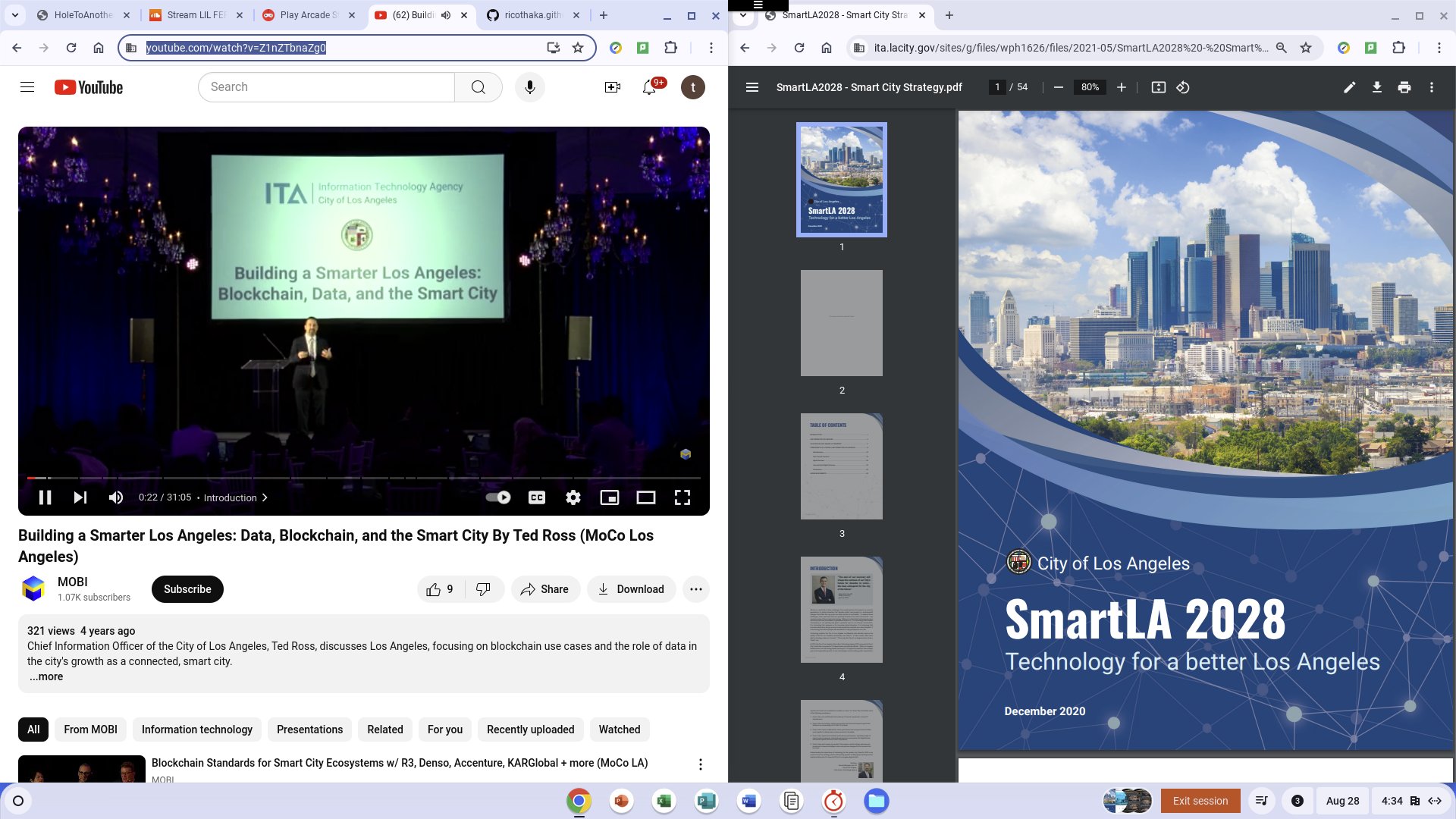
[Building a Smarter Los Angeles: Data, Blockchain, and the Smart City By Ted Ross (MoCo Los Angeles)](https://www.youtube.com/watch?v=Z1nZTbnaZg0) [Smart LA SMartCities PDF](https://ita.lacity.gov/sites/g/files/wph1626/files/2021-05/SmartLA2028%20-%20Smart%20City%20Strategy.pdf)
Normani I dont know whats going on in your world. But I got my worknotes sored here. BlockQuote is heavily filtered at the library so I dont know what it really looks like
[Use Jekyll Front Matter Defaults to set your layouts](https://www.johanbleuzen.fr/blog/use-jekyll-front-matter-defaults-set-layouts)
[#HTML5 video source examples ](https://codepen.io/thakarashard/pen/BagQQaR?editors=1000)
[Attribute selectors](https://developer.mozilla.org/en-US/docs/Web/CSS/Attribute_selectors)
The CSS attribute selector matches elements based on the element having a given attribute explicitly set, with options for defining an attribute value or substring value match.[full article on mozilla_developer](https://developer.mozilla.org/en-US/docs/Web/CSS/Attribute_selectors)
```css
img[alt="whiteslavery"] { max-width: 20%;}
img[alt="whiteslavery40"] { max-width: 40%; transform: rotate(45deg);}
```
markdown


HTML5
img[alt="whiteslavery"] { max-width: 20%;}
img[alt="whiteslavery40"] { max-width: 40%; transform: rotate(45deg);}
[Styling Gist embeds with CSS](https://danielbernal.co/styling-gist-embeds-with-css/)
[CSS Box Sizing Module Level 3](https://www.w3.org/TR/css-sizing-3/#min-content)
### Passing parameters to includes
You can also pass parameters to an include. For example, suppose you have a file called `note.html` in your `_includes` folder that contains this formatting:
```liquid
Note:
{{ include.content }}
```
[ALiSTAPART_The Bathing Ape Has No Clothes (and other notes on the distinction between style and design)](https://alistapart.com/article/bathingape/) [ALiSTAPART_Design Choices Can Cripple a Website](https://alistapart.com/article/designcancripple/) [ALiSTAPART_Good Designers Redesign, Great Designers Realign](https://alistapart.com/article/redesignrealign/) [ALiSTAPART_Designing Through the Storm](https://alistapart.com/article/throughthestorm/) [ALiSTAPART_Staying Motivated](https://alistapart.com/article/stayingmotivated/) [ALiSTAPART_Understanding Web Design](https://alistapart.com/article/understandingwebdesign/) [ALiSTAPART_Marry Your Clients](https://alistapart.com/article/marry-your-clients/) [ALiSTAPART_Personality in Design](https://alistapart.com/article/personality-in-design/) [ALiSTAPART_Before You Hire Designers](https://alistapart.com/article/before-you-hire-designers/) [ALiSTAPART_Planning for Accessibility](https://alistapart.com/article/planning-for-accessibility/) [ALiSTAPART_Trans-inclusive Design](https://alistapart.com/article/trans-inclusive-design/) [ALiSTAPART_Immersive Content Strategy](https://alistapart.com/article/immersive-content-strategy/) [ALiSTAPART_Designing Inclusive Content Models](https://alistapart.com/article/designing-inclusive-content-models/) [NYPLBase The Library's rapid prototyping system and design pattern library](nypl.github.io/NYPLBase/styleguide/index.html) [NYPL_STYLEGUiDE_ARCHiVE](https://web.archive.org/web/20080617044807/http://www.nypl.org/styleguide/)
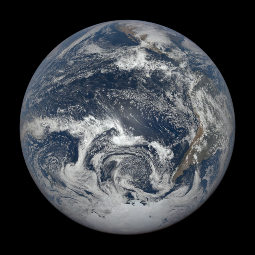
[Mars](https://science.nasa.gov/mars/) is the fourth planet from the Sun, and the seventh largest. It’s the only planet we know of inhabited entirely by robots.

Normani please look at this old post, it is a marker for how long i have been focused on Programming CSS
# SUNDAY, NOVEMBER 21TH, 2021
# Im working on CSS
Since I'm publishing using [##GiTHUB_PAGES](https://pages.github.com/), alot of administration needs are met from my [GiTHUB_ACCOUNT](https://github.com/ThakaRashard), I can focus on coding. [Cascading Style Sheets is a legit programming language for the browser](http://www.csszengarden.com/216/). Using the site David Shea Started, I can get this Jekyll account to another level. I really need this book [The Zen of CSS](https://www.goodreads.com/en/book/show/565.The_Zen_of_CSS_Design) he published. I have to create navigation to my resume and create a contact page. Im using [GiTHUB Repositories](https://docs.github.com/en/repositories/creating-and-managing-repositories/about-repositories) to manage individual pages right now because it is a small site and I want [psychological separation](https://www.separationadvice.net/psychological-separation/) which social media does not provide. I was blackballed on Linkedin for just not knowing enough for my age, and my family+romance life. Every woman that committed to me was sold into sex slavery and kidnapped by ##INSTAGRAM_PiMPS_and_MARKETED_iN_FACEBOOK_BROTHELS. They are still trafficked as prostitutes. IT people in the DEVOPS generation often fool themselves into thinking prostitution is normal and the family which is affected is the problem. This view has left people with familes discriminated against in the ##IT_MARKETPLACE, but here in Los Angeles after 2 years of homelessness, I sense my luck changing... So Im working hard to clean up my image and reputation outside social media, which has brought me closer to my family
## I_FOUND_EVERYONE ALiVE_HERE_IN_SOUTHERn CALIFORNIA
. I cant test touch screens at this point from [Palmdale Public Library's](https://cityofpalmdale.org/318/Palmdale-City-Library) traditional [Optiplex desktops](https://www.dell.com/en-us/work/shop/desktops-all-in-one-pcs/optiplex-5040-series-desktops/spd/optiplex-5040-desktop)
[Memphis police release photos of 2 suspects wanted over Young Dolph's shooting death](https://www.npr.org/2021/11/19/1057194115/memphis-police-suspects-wanted-young-dolph-murder)
[Another bill again-Tony Rebel](https://www.youtube.com/watch?v=U9ZLAgyn2-Q) [McDonalds Ronald McDonald and Mayor McCheese in Space, 1978](https://youtu.be/nmL6pMQMBBk?si=LSk6f74OXwuxsFkq) [Another bill again-Tony Rebel](https://www.youtube.com/watch?v=U9ZLAgyn2-Q) [Astronaut Chick](https://www.youtube.com/watch?v=6kAsPbbp8GI) [Truth Gonna Hurt You](https://youtu.be/WBxjt78PG3s?si=NMtQTDZ7_AZMERGy) <~ late for work ? idk
### [Tesla Coils at Griffith Observatory video](https://griffithobservatory.org/)
[Tesla coil is an electrical](https://en.wikipedia.org/wiki/Tesla_coil) resonant transformer circuit designed by inventor Nikola Tesla in 1891.[1] It is used to produce high-voltage, low-current, high-frequency alternating-current electricity.[2][3] Tesla experimented with a number of different configurations consisting of two, or sometimes three, coupled resonant electric circuits.
Sorry, your browser doesn't support embedded videos, but don't worry, you can
download it
and watch it with your favorite video player!
### [FlexBox Demo](https://codepen.io/thakarashard/pen/WNBVzWr)
MP4
video.
[The Result](ricothaka.github.io/playlist)


 RelatedTweet - Mission Voyager @nasa


 {#id .myClass width=40 height=50}
 The Bay Foundation RelatedTweet


 RelatedTweet RELATEDTWEET

 RelatedTweet


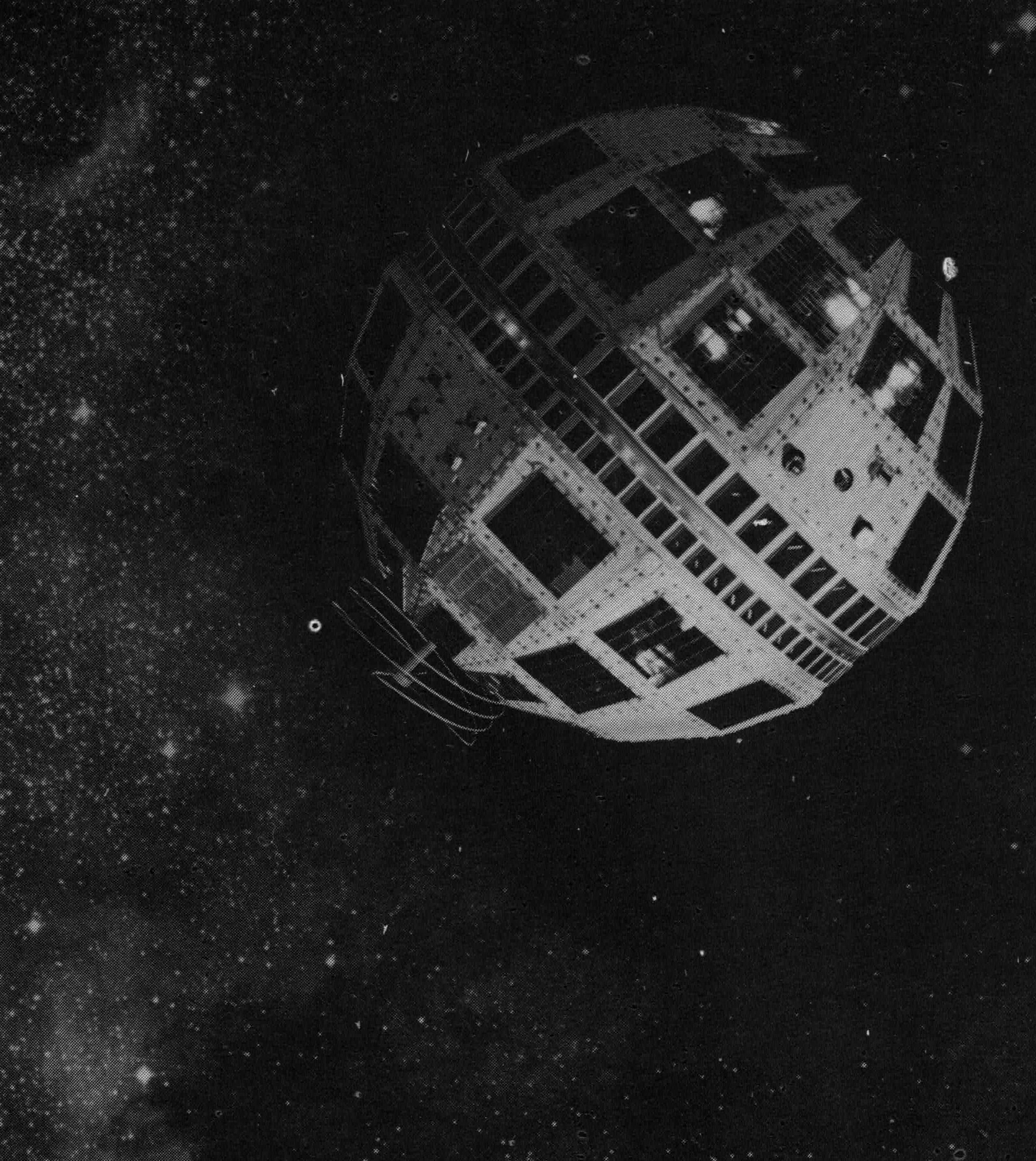 AT&T Archives: Telstar!
Telstar 1
AT&T Archives: A Modern Aladdin’s Lamp, about vacuum tubes,1940
AT&T Archives: Telstar!
Telstar 1
AT&T Archives: A Modern Aladdin’s Lamp, about vacuum tubes,1940