
./HoleToAnotherUniverse=>
BubbleGumPop
Ocean
Drought
ev
rape
Los Angeles County
Iss
me
Ga
Daily
Ed Tutorial
computing
RelatedTwT
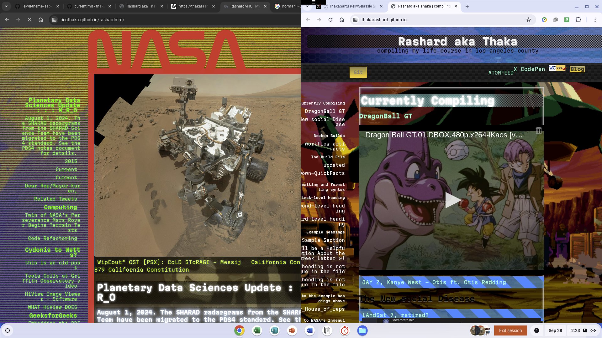
MRO
GDS
CovidDump
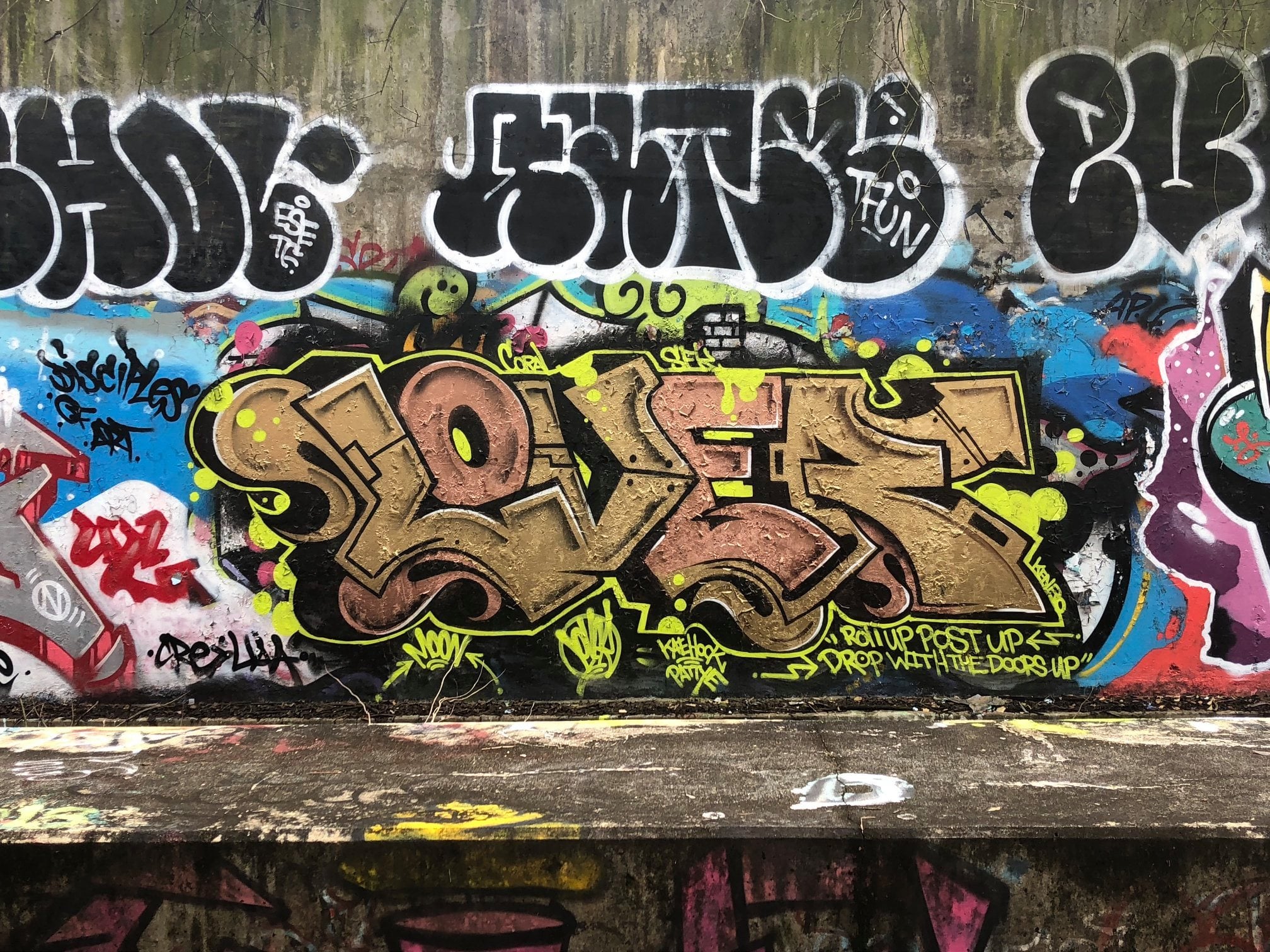
GraffShit
Arcade
Guidelines for Proposers to ROSES Dual-Anonymous Peer Review Programs NASA Solicitation and Proposal Integrated Review and Evaluation System
Bookworms Beware: Hackers Launch Cyberattacks On Libraries Globally
Sausalito, Calif. – May 15, 2024
Taylor Fox spent five years working at libraries before joining Cybercrime Magazine as a media coordinator. The former page and clerk dug up some interesting market data on a disturbing trend that is affecting bookworms across the world: Our libraries are under cyberattack. ReadMore

Terminator 2
T2 La°River GraffitiVerite Reimagining The Los Angeles River - PBS
N64
Alabama Barker - Cry Bhabie (Official Music Video)
BubbleGumPop
Ocean
Drought
ev
rape
Los Angeles County
Iss
me
Ga
Daily
Ed Tutorial
computing
RelatedTwT
MRO
GDS
CovidDump
GraffShit
Arcade
Graffiti Rock

Speed up your Jekyll builds - Mike Neumegen Use front matter to add metadata to your content. GoHUGO - FRONTMATTER Docs to: @nasa-jpl manessa is Kash Doll have her come in this is an interview with her at club Shay Shay I never saw Coral again so my daughter is really missing with a woman named Kash Doll that talks to like retired NFL players at a place named club shay shay I want to know a club shay shay let me see Coral club shay shay htmlCleaner-WEBTOOL
Learning FlexBox
RelatedTweet Mastering wrapping of flex items :: completed
BubbleGumPop
Ocean
Drought
ev
rape
Los Angeles County
Iss
me
Ga
Daily
Ed Tutorial
computing
RelatedTwT
MRO
GDS
CovidDump
GraffShit
Arcade
coursework @nasa flexSizing tupperware ricothaka
Dear_NormANi
I have been working from Mozilla Web Developers Documentation. ITs @nasa-jpl coursework if you file it right… Can you help me update whoever i need to talk to on this day about my frontend programming skills. When I set up the date theres never any touch, so we can keep that role, u your body ok… i dont own u, an if erika dead, please give me a good story so i can wed yo fine ass ° Moon to Mars Program π NASA org Chart OrgChartBae SpaceWeatherhthatsMEblackgirlscode MarsSampleReturn ,💯✌️👀🙇🏾♂️🌬️🍦🗿🕋🕌🏬🛕⛪💒📟📠🔌💻🖥️⌨️📀💿💾💽📞☎️📱🪫### Mars MissionObjectives MArs Reconnocinse Orbiter WipEout® OST [PSX]: CoLD SToRAGE - Messij California Constitution 1879 California Constitution Equal Rights Amendments: State Provisions 1849 California Constitution (spanish) PDS Cartography and Imaging Sciences Node - WebTool Computer Ethics 4th ed. Deborah G. Johnson
Ocean
Drought
ev
rape
Los Angeles County
Iss
me
Ga
Daily
Ed Tutorial
computing
RelatedTwT
MRO
GDS
CovidDump
GraffShit
Arcade

Mars Reconnaissance Orbiter
Jim Taylor, Dennis K. Lee, and Shervin Shambayati
6.1 Mission Overview
The Mars Reconnaissance Orbiter (MRO) [1, 2] has a suite of instruments making observations at Mars, and it provides data-relay services for Mars landers and rovers. MRO was launched on August 12, 2005. The orbiter successfully went into orbit around Mars on March 10, 2006 and began reducing its orbit altitude and circularizing the orbit in preparation for the science mission. The orbit changing was accomplished through a process called aerobraking, in preparation for the “science mission” starting in November 2006, followed by the “relay mission” starting in November 2008. MRO participated in the Mars Science Laboratory touchdown and surface mission that began in August 2012 (Chapter 7). ReadMore - PDF NASA’s Mars Reconnaissance Orbiter searches for evidence that water persisted on the surface of Mars for a long period of time. ActiveMission - DoD

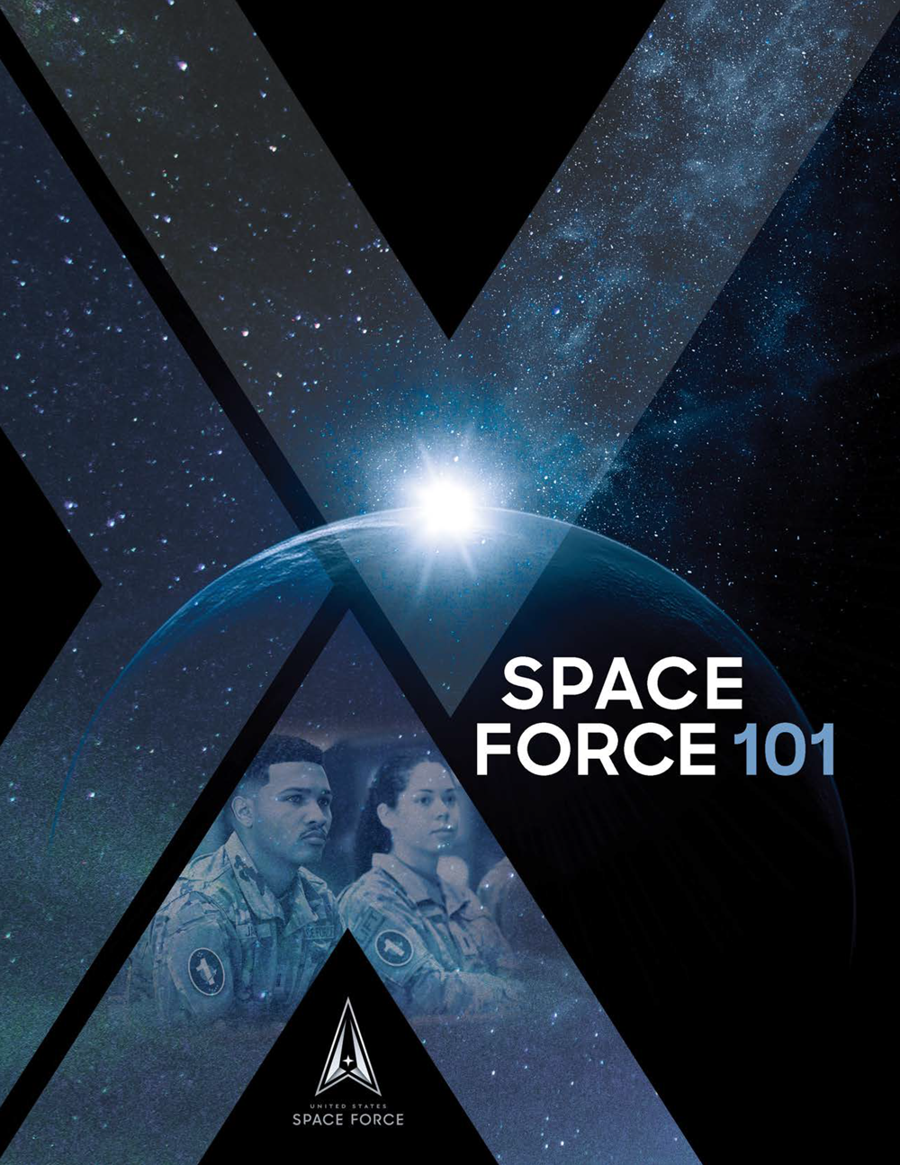
About the United States Space Force
![]() The U.S. Space Force was established on Dec. 20, 2019, creating the first new branch of the armed services since 1947. The establishment of the USSF resulted from widespread recognition that space is a national security imperative. When combined with the growing threat posed by strategic competitors in space, it became clear that there was a need for a military service focused solely on pursuing superiority in the space domain. US SPACE Force 101 - PDF
The U.S. Space Force was established on Dec. 20, 2019, creating the first new branch of the armed services since 1947. The establishment of the USSF resulted from widespread recognition that space is a national security imperative. When combined with the growing threat posed by strategic competitors in space, it became clear that there was a need for a military service focused solely on pursuing superiority in the space domain. US SPACE Force 101 - PDF
](https://www.spaceforce.mil/portals/2/Documents/SF101/ussf_101.png)
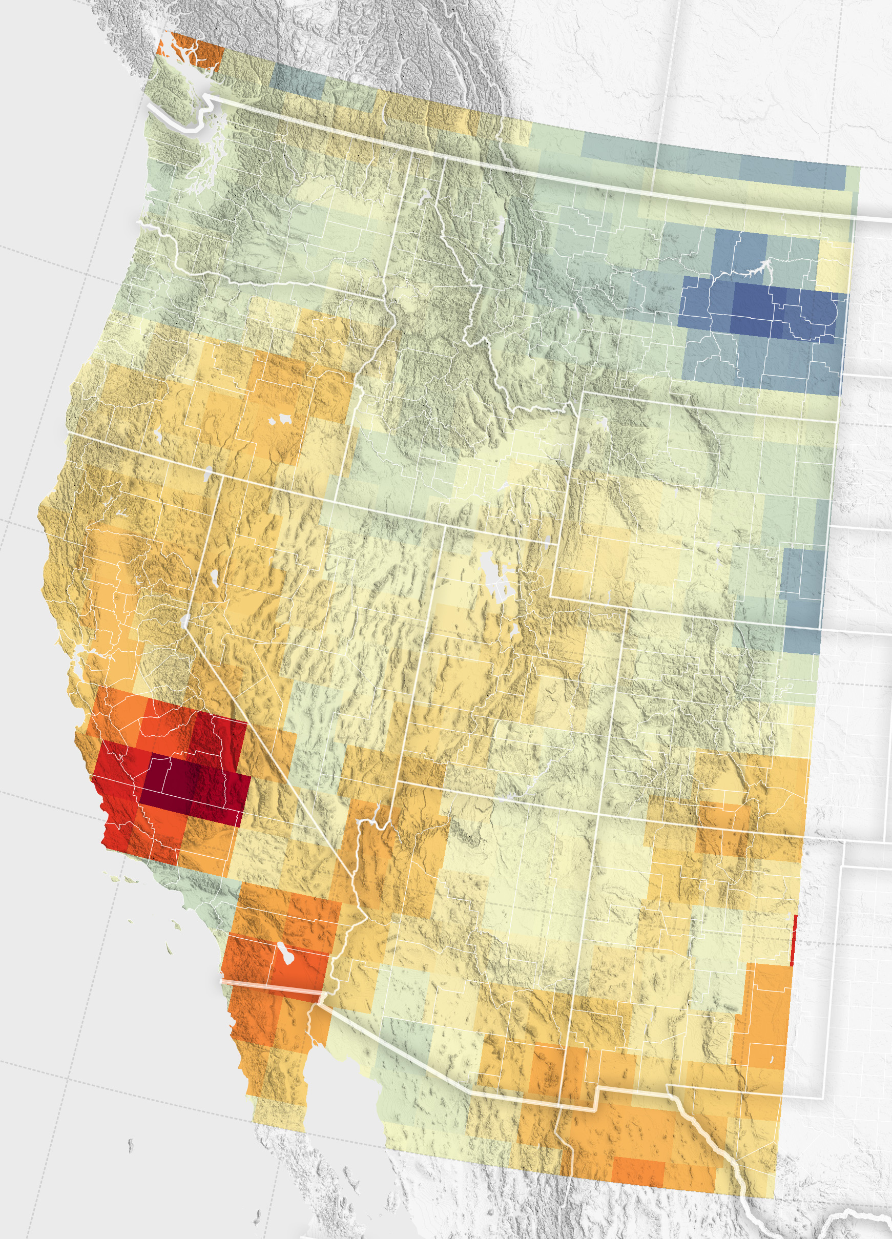
Groundwater Declines in the U.S. Southwest;
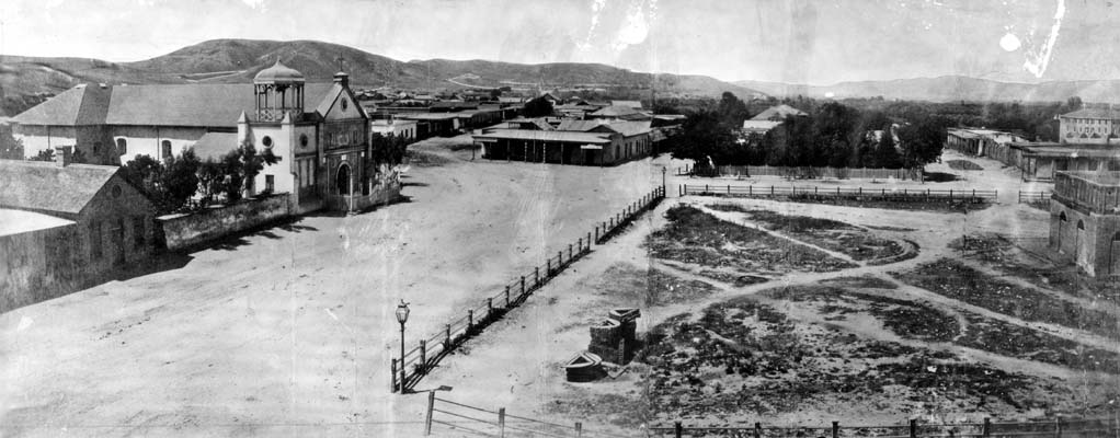
Los Angeles Plaza 1869
Thick Terrain #3 animation - Wakana Y.K.

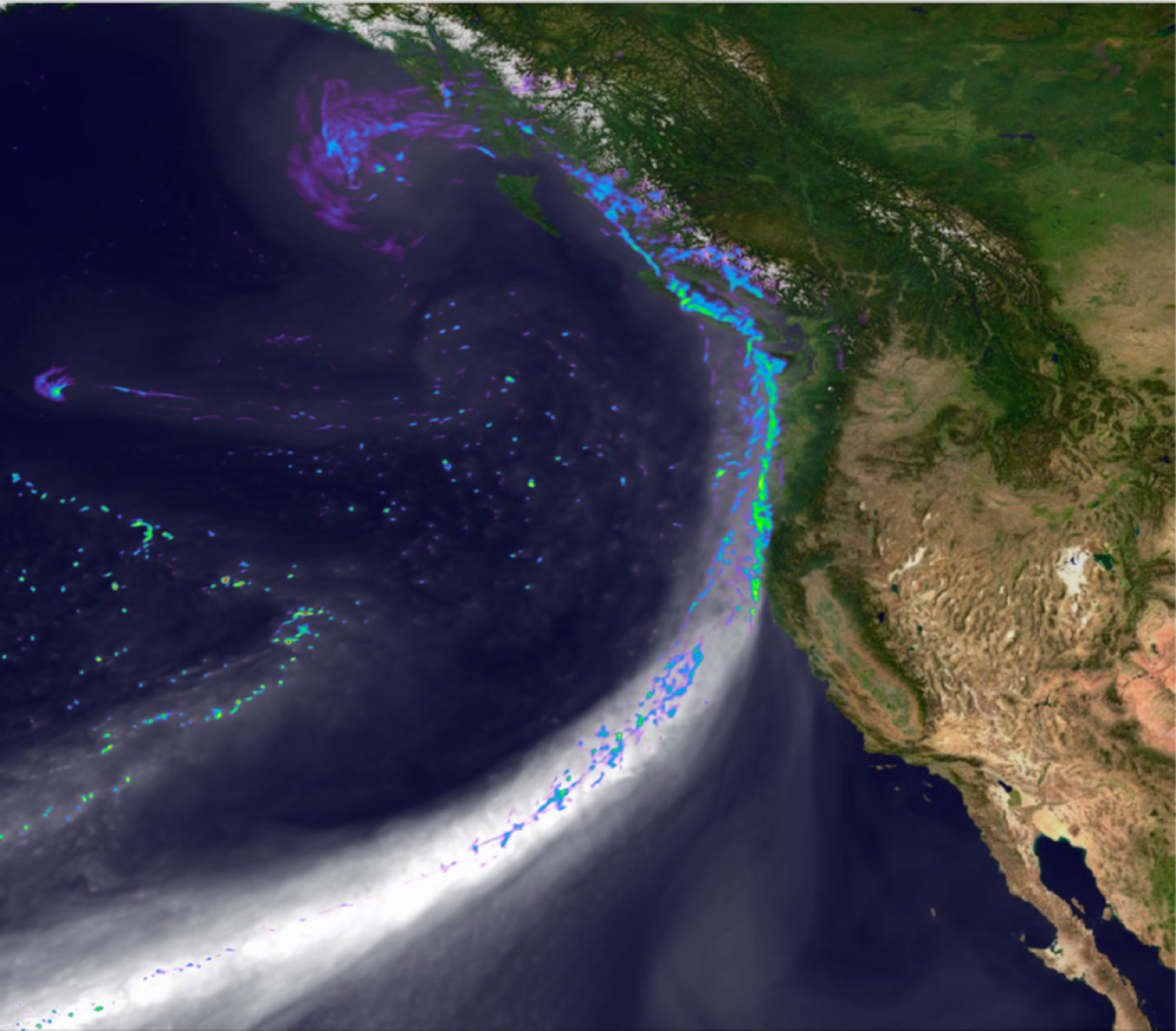
Vortex NasaWorlDViEw - California Coast


@blackgirlscode @normani ThursdayDump vlogscreen-20250227-090209 theres LA_RiVER Footage for today @Nasa-JPl @usgs
National Water Dashboard Related Tweet

cellular magic mirror


‘
EcoStress DataUpdate RelatedTweet Elon Musk Calls For SpaceStationDeorbiting 2cents


map or dams to resiovior chlorophyll map ::::2025FEB21-CHLOROPHYLL_REPORT ill make the google earth wrap later the internet is really infected by CloudFront bullying, the library did not pay they @cisco bill @nasa
504 Error
The request could not be satisfied.
CloudFront attempted to establish a connection with the origin, but either the attempt failed or the origin closed the connection. We can’t connect to the server for this app or website at this time. There might be too much traffic or a configuration error. Try again later, or contact the app or website owner.
If you provide content to customers through CloudFront, you can find steps to troubleshoot and help prevent this error by reviewing the CloudFront documentation.
Generated by cloudfront (CloudFront) 504 Gateway Time-out
Request ID: IhGo-_3uy-zG1glJxTuJBEG3lLoJXICXM4icUnim7CfSue3H1em5zQ==


git hub work on the train
Documentary: Raised on Porn – the new sex education - watch - RiOTiMEs In today’s world, porn is ubiquitous. It’s everywhere, - https://sexandrelationshiphealing.com/
Twitter Follow i got this off DefConRadio on SOMAfm now Run & Tell That
sonta “Your Mistake” OfficialVideo
Soil Moisture Visualizer - AirMOSS
Saturday Morning Breakfast @nasa-jpl
git hub work on the train @blackgirlscode .. La county LosAngeles California Services Locator -WebTooL
@nasa Robin_M_R_O is that u? i found a couple daacs i


How to show all images within a folder directory?
@blackgirlscode : : Normani i joined r/jekyll on the bubblegumpop email
@nasa Robin_M_R_O is that u? i found a couple daacs i

About the LAADS DAAC
The Level-1 and Atmosphere Archive & Distribution System Distributed Active Archive Center (LAADS DAAC), located in Greenbelt, MD, primarily archives and distributes data on clouds, water vapor, and aerosols in Earth’s atmosphere as well as key instrument data for NASA, NOAA and European Space Agency missions. Secondarily, LAADS DAAC serves as a backup source for Moderate Resolution Imaging Spectroradiometer (MODIS) and Visible Infrared Imaging Radiometer Suite (VIIRS) land products. ReadMore
2024 Atlantic Hurricane Season
The NASA Terra and Aqua satellites, each which carries a MODIS imager, are currently planning to cease science data collection January 2027 and August 2026, respectively. After the end of satellite operations, a final MODIS calibration will be developed followed by a complete reprocessing of all MODIS data; this is planned for completion by October 2029. ReadMore


Rashard Iman KElly - Nasa EarthSciences @nasa-jpl


Commit 4a8760a
LA_RiVER_BOOK
RabbitHeadHistoryRelife
FavoriteRadio
Manasseh Warner, NCC HollywoodBae? DAM_LiST LA_SNOW
This document is the AMMOS Catalog, Version 5.1 for the Multimission Ground Systemand Services (MGSS) Program, Interplanetary Network Directorate (IND) Office The capabilities described in this AMMOS Catalog are intended to serve as guidance
and as the ‘gold source’ capability descriptions when developing Service Level
Agreements (SLAs) with mission customers
Rover ControL an Planning Software AMMOS offers an Suite of tools for Real-time Monitoring and Control of a Spacecraft
part of the - Ground Data System (GDS) tool suite
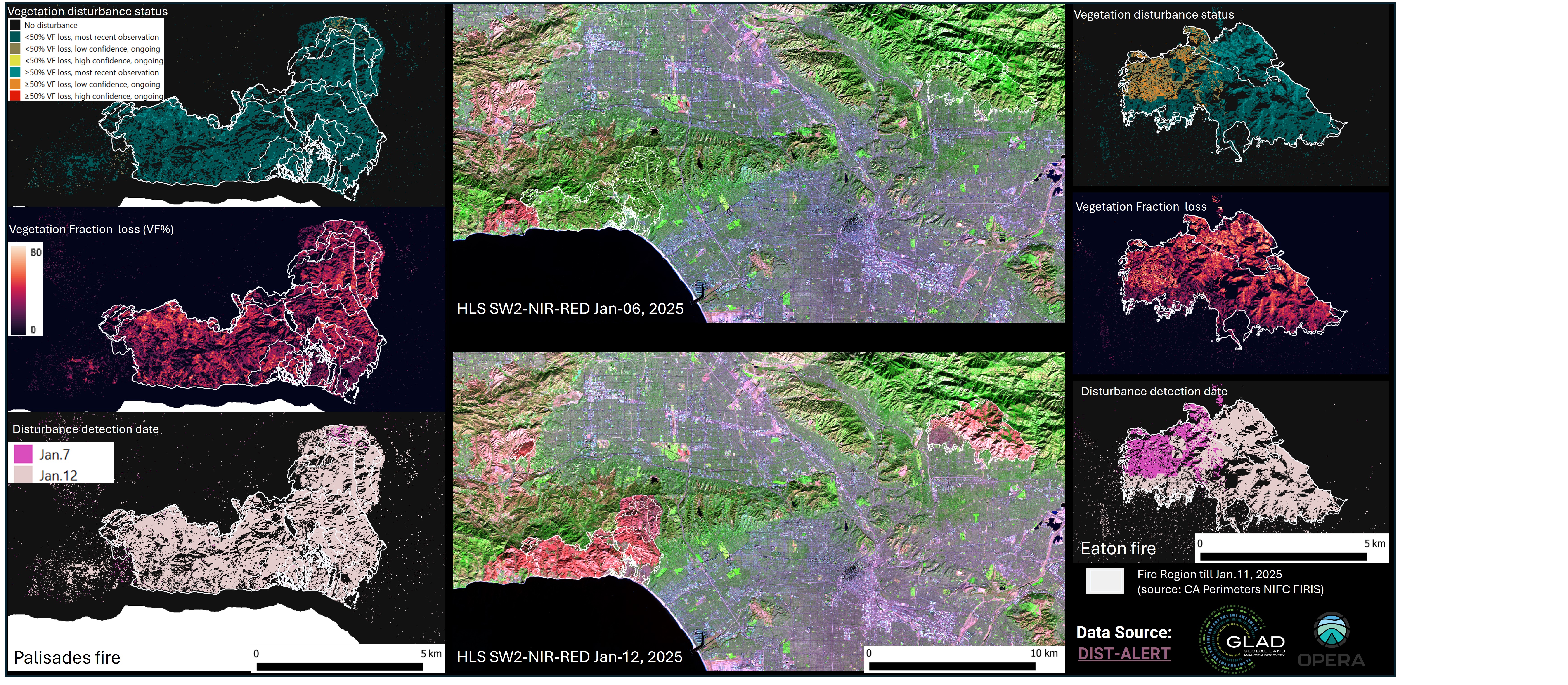
Ground & Flight Data Systems Group creates systems to facilitate transmission and processing of data between spacecraft, rovers, satellites, ground control, and distributed mission teams. Data ranges from communications, telemetry, and Integrated Systems Health Management (ISHM) data, to planetary, astrophysical, medical, and biological science research data and analytics. Ground processing of data is accomplished by science pipeline data systems, which transform raw, uncorrected, uncalibrated data into usable products for the science community. GFDS designs systems to satisfy carefully defined and documented user requirements involving the secure handling of sensitive and irreplaceable mission data. The group supports space and planetary exploration missions, as well as Earth and space sciences, small satellite, and aeronautics missions and projects. The Mars 2020 Ground Data System Architecture The Mars Observer Camera Ground Data System https://www.msss.com/mars/observer/camera/papers/gds_papers/aiaa.html Eaton Fire Leaves California Landscape Charred
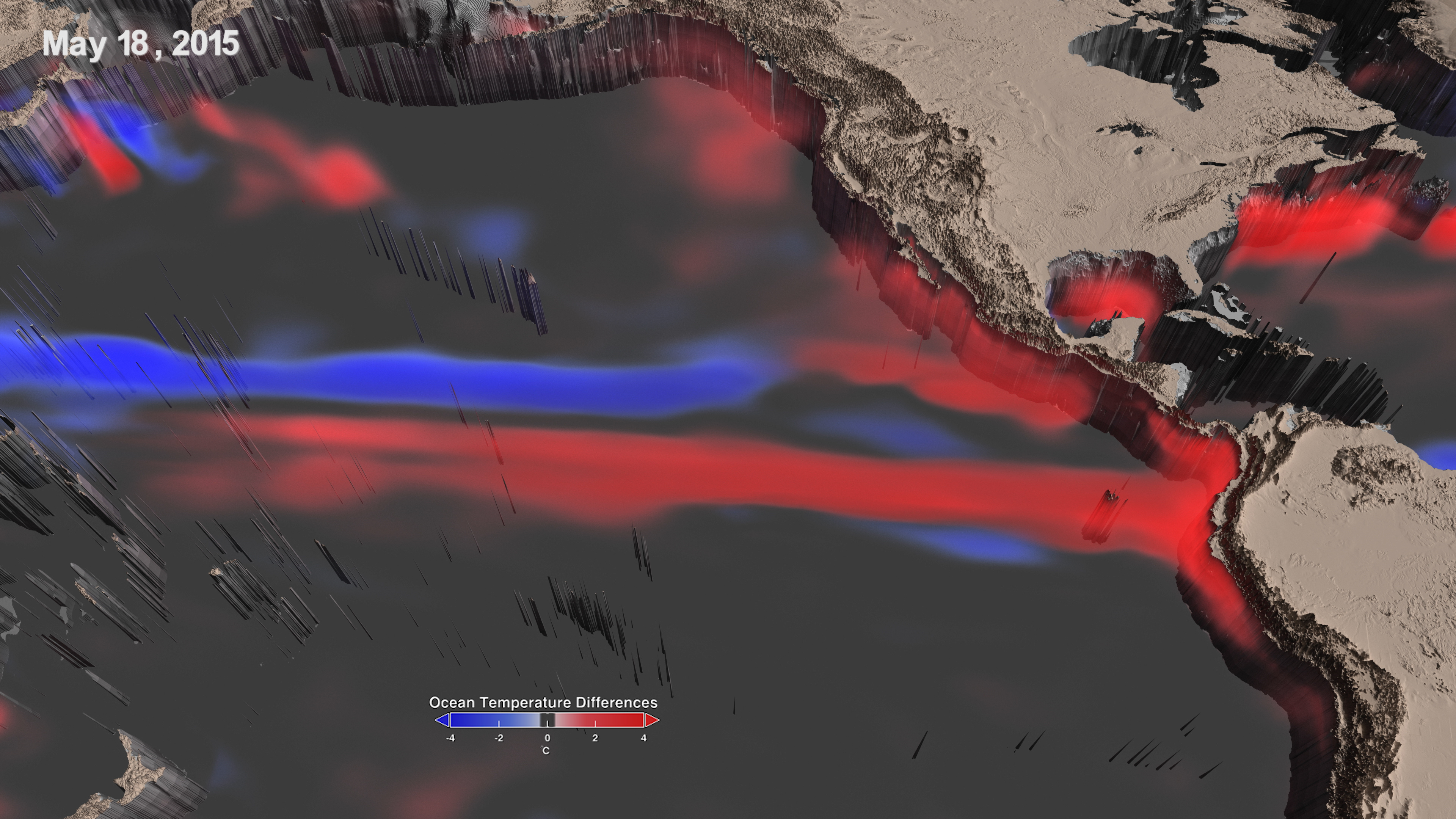
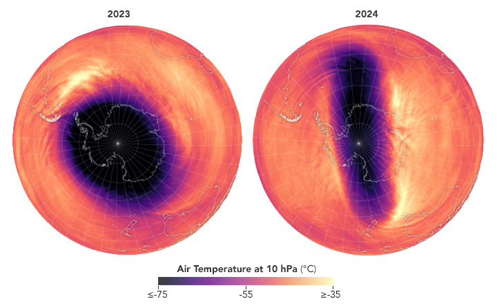
El Niño Southern Oscillation
KD Diary - KashDoLL
@blackgirlscode idk if Normani is Kashdoll or They sisters but they / it has been my friend above all an i want her to get an audience that is really into hearing a story like a magazine you pick up. That will protect her from predators. Its a pattern for you all
Summer of ‘67 - how Detroit changed forever in 5 days Detroit Classic - The Rise and Fall of Detroit’s Black Bottom” Kash Doll On Drake, Kendrick Lamar, Chief Keef, Detroit, Men, Relationships & Performs! Kash Doll Opens Up About Home Invasion Involving Shootout With Tracy T Kash Doll Says She Was Robbed of $500,000 Worth of Jewelry Kash Doll Reveals There Were Multiple Arrests Following Attempted Home Robbery - HollywoodUnlocked RAPPER KASH DOLL CLAIMS SHE LOST $500K IN CAR BURGLARY While Shooting Music Vid!!! - TMZ Mar 14, 2018 — To celebrate her birthday, Detroit rapper and rising hip-hop starlet Kash Doll drops a new mixtape entitled Brat Mail
PrivateSnafu: Rumors (1943)
https://svs.gsfc.nasa.gov/31309/
Two Decades of Soil Moisture from Space
These maps combine data from the Gravity Recovery and Climate Experiment (GRACE) and GRACE Follow-On (GRACE-FO) with other satellite and ground-based measurements to model the relative amount of water stored at three different depths READMORE NiLSen-Animator
@tesla @spacex @nasa-jpl @whitehouse @deptofdefense
I saw some scary graffiti threatening elon musK


Related Message To RepKamlager
review [#myGitHub] 4


Exoplanet Count Tops 5,000 EXOPLANET_ARCHiVE 5kDOWNLOAD

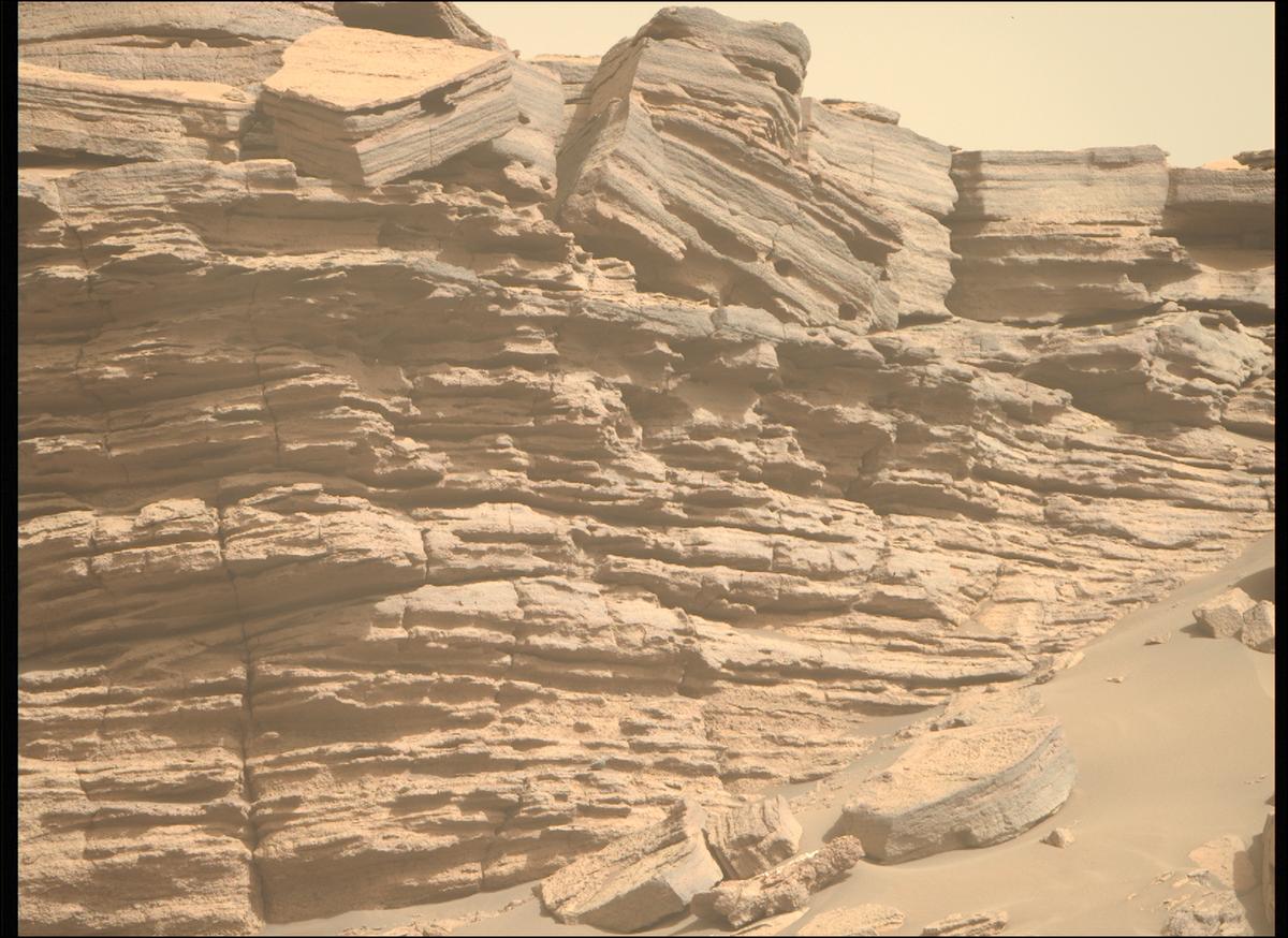
Mars Hand Lens Imager (MAHLI) Sol 1245:

NASA’s Mars rover Curiosity acquired this image using its Mars Hand Lens Imager (MAHLI), located on the turret at the end of the rover’s robotic arm, on February 6, 2016, Sol 1245 of the Mars Science Laboratory Mission, at 11:02:10 UTC.
When this image was obtained, the focus motor count position was 12660. This number indicates ReadMore RelatedTweet-CuriosityWebSiteError LARiVER GraveYard_EAV_RELATiONSHiPS


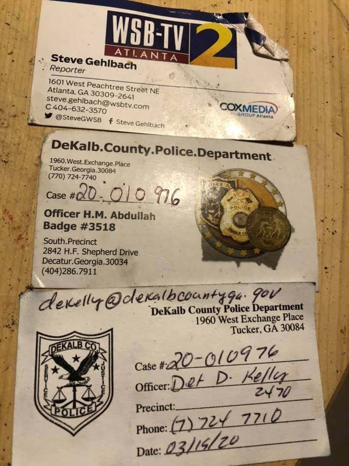
https://t.co/CnCHLEQAv2 #AVIRIS3 L1B #CalibratedRadiance,Facility Instrument Collection #LosAngelesWildfires @GavinNewsom @NewsHour @MayorOfLA https://t.co/fpuAZ7oBQy the 4th one is #eatoncanyonfire @VeronicaMcG @nasajpl #NORMANI #doiHAVEbeef wit @DeKalbCountyPD @BlackGirlsCode? pic.twitter.com/TjBrIlknXI
— ThakaSartu KellySelassie (@thakasartu) February 1, 2025
Planetary Image Locator Tool @usgs Explore NASA’s largest raw spacecraft imagery archive
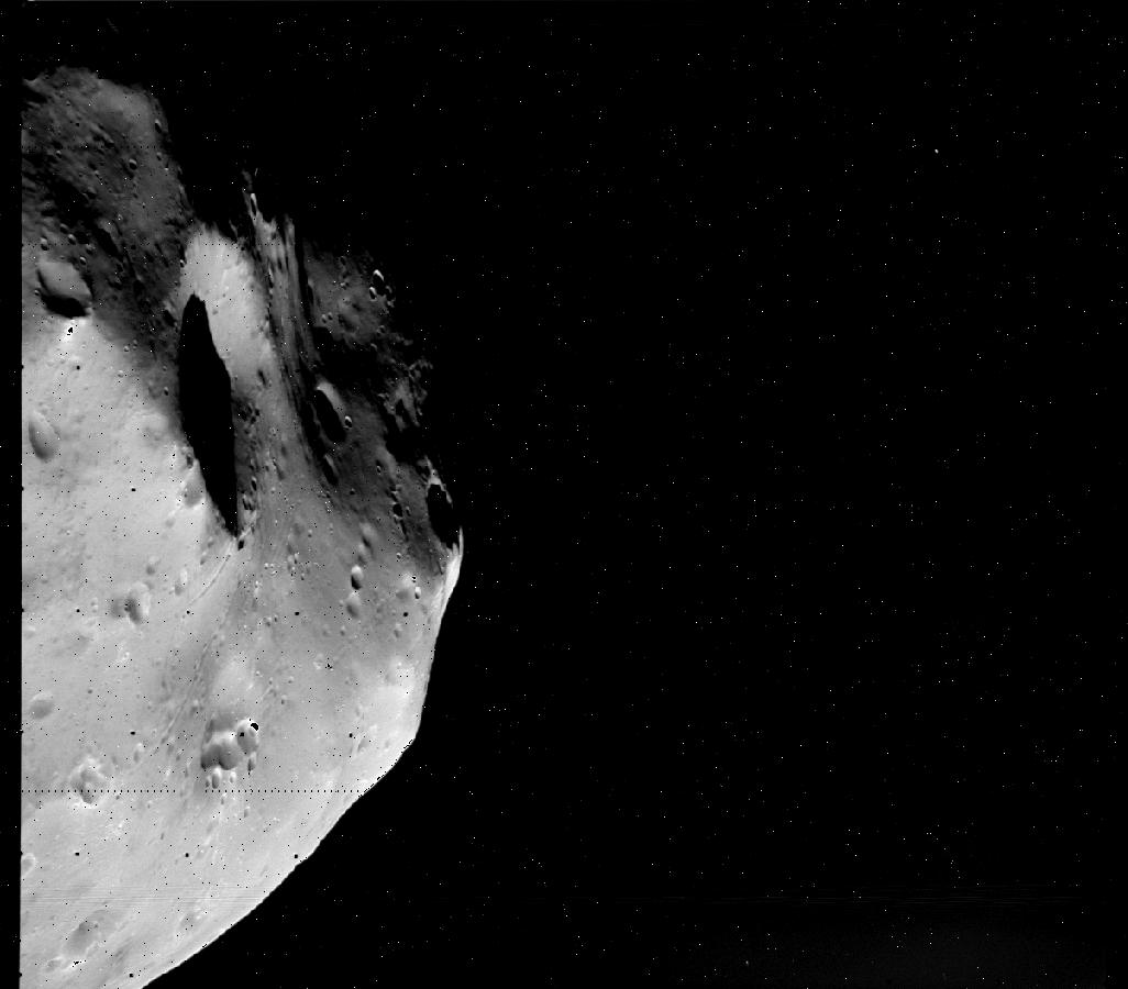
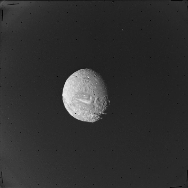
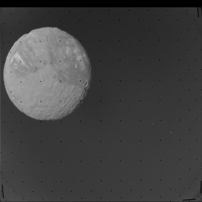
![]() Viking - Orbiter view of the Martian satellite Phobos - @NASA MiSSiONiNDEX
Viking - Orbiter view of the Martian satellite Phobos - @NASA MiSSiONiNDEX
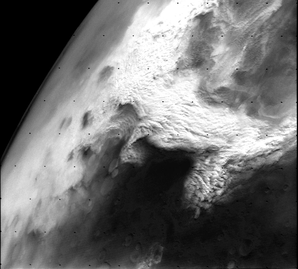
 PIA02985: Dust storm in the Thaumasia region of Mars
RAnger 8
Voyager Interstellar Mission (VIM)
The mission objective of the Voyager Interstellar Mission (VIM) is to extend the NASA exploration of the solar system beyond the neighborhood of the outer planets to the outer limits of the Sun ’s sphere of influence, and possibly beyond.
Oort Cloud and Scale of the Solar System (Infographic)
 TDRS-K Video File
Near Space Network
TDRS-K Video File
Near Space Network
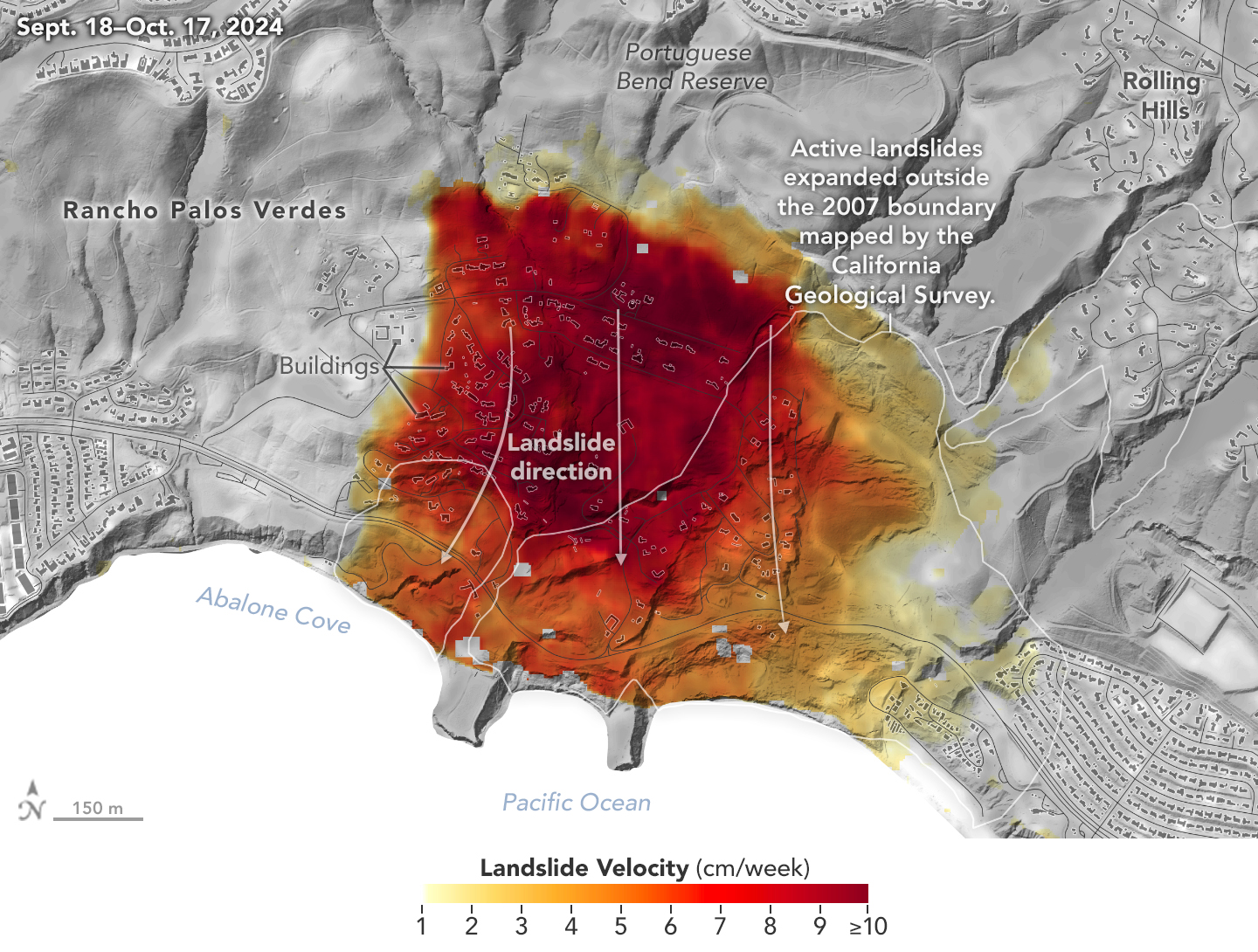
Los ANGELES Area LandSlides
NASA Radar Imagery Reveals Details About Los Angeles-Area Landslides RelatedTweeT
Researchers at NASA’s Jet Propulsion Laboratory in Southern California used data from an airborne radar to measure the movement of the slow-moving landslides on the Palos Verdes Peninsula in Los Angeles County - ReadMorE
What is the Earth’s “water cycle?”
The water cycle, also known as the hydrologic cycle, describes where water is stored on Earth and how it moves.

There are two ways in which water moves from the ground to the atmosphere as part of the hydrologic cycle: evaporation and transpiration. Transpiration is basically evaporation of water from inside plant leaves. - Learning Lesson: Leaf it to Me @NOAAGov @nasa-jpl Transpiration in Plants: Its Importance and Applications Evaporation and Transpiration Basic Concepts Transpiration - What and Why?
The Biology of Transpiration. From Guard Cells to Globe
Transpiration in higher plants accounts for about three-quarters of the water that is vaporized at the global land surface and one-eighth of that vaporized over the entire globe. The availability of water is one of the major factors restricting terrestrial plant production on a global scale. Susanne von Caemmerer 1, Neil Baker 1


The Legend of Zelda
franchise created by Japanese game designers Shigeru Miyamoto and Takashi Tezuka… Amazing
![]() Zelda wow
FANDOM WiKi NinTenDo inside cart photos
Zelda wow
FANDOM WiKi NinTenDo inside cart photos


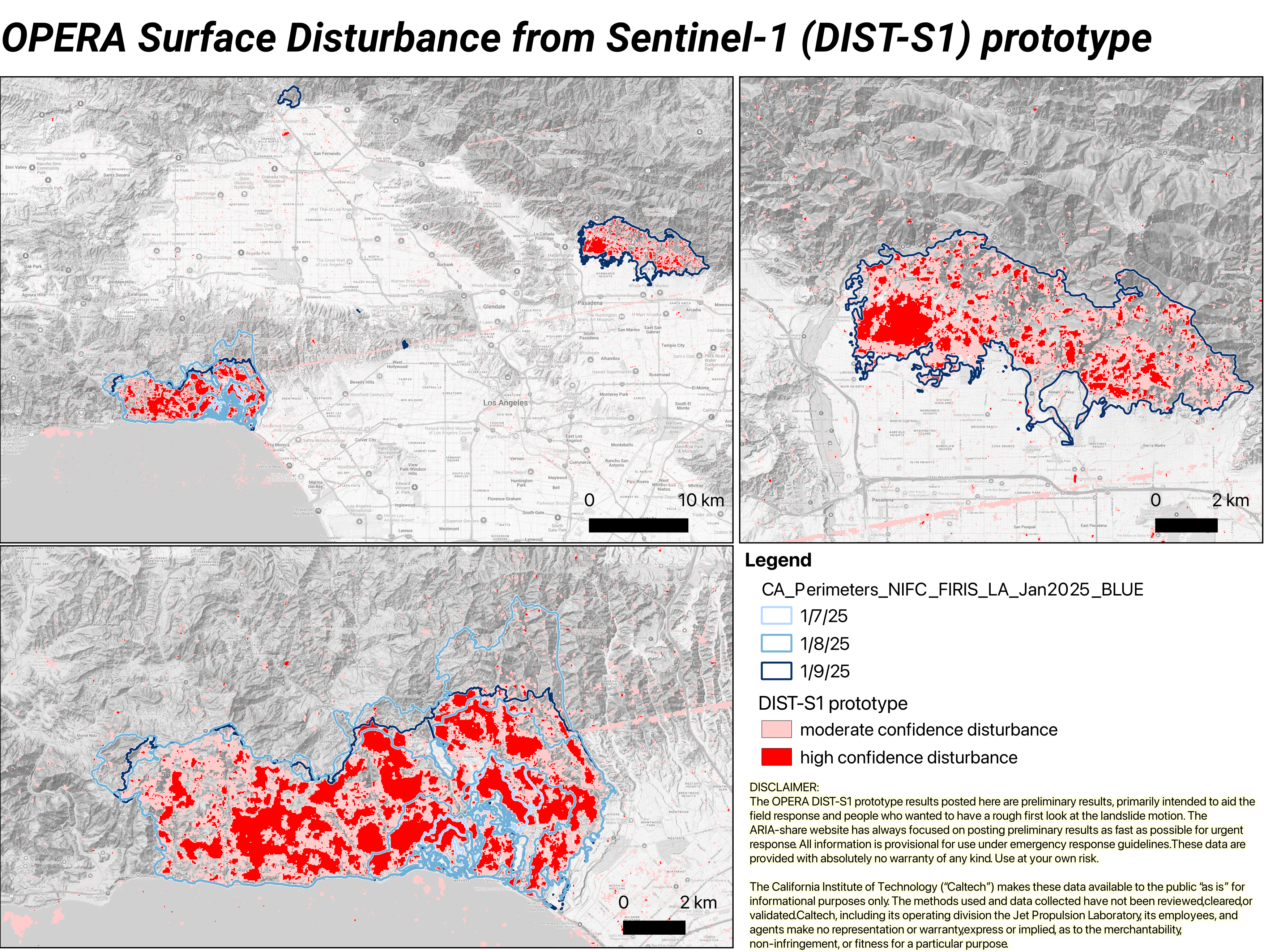
ARIA/OPERA Surface Disturbance from Sentinel-1 (DIST-S1) prototype
Researchers working with the Advanced Rapid Imaging and Analysis (ARIA) and Observational Products for End-Users from Remote Sensing Analysis (OPERA) teams at NASA’s Jet Propulsion Laboratory, Pasadena, California, created the OPERA Surface Disturbance Alert from Sentinel-1 (DIST-S1-ALERT) prototype product suite to create maps of surface disturbance due to ongoing wildfires in Los Angeles County in January 2025. The land Surface Disturbance product (DIST) maps disturbance detected when there is a change outside a historical norm using optical or SAR imagery. DIST Product Suite DAAC - OPERA_L3_DIST-ALERT-HLS_PROVISIONAL_V0 v000
NASA’s Jet Propulsion Laboratory unscathed by Eaton fire, but not its workforce - LATiMES <~ @datadesk
FoR LATER ARiA


GLOBE Program Overview
With the support of NASA and the federal science agencies that sponsor GLOBE, namely the National Oceanic and Atmospheric Administration (NOAA), the National Science Foundation (NSF) and the U.S. Department of State (DoS), GLOBE engages learners in the scientific process and advances scientific literacy and science diplomacy. Through GLOBE’s community engagement, the program serves as a bridge between the researchers of today and those of tomorrow. READMORE

PIA26339: Checking the Cover on Perseverance’s SHERLOC
PIA26377: Perseverance Drives Backward Up Jezero Crater’s Rim
@blackgirlscode
Dear Normani
Im going to truncate this and do like a wordcloud using a 4 loop to speed up the page. If u dont like the idea, i will get a sign. You have data there for your car accident when u lost control … @nasa @nasa-jpl

Los Angeles Fires : Palisades : Pepperdine

FLiGHTLiNES.CSV Coast
Commit 4a8760a
 RelatedTweet RELATEDTWEET

 RelatedTweet


Missing from My world
maybe its good, idk but i wanna know we ok with eachother @blackgirlscode

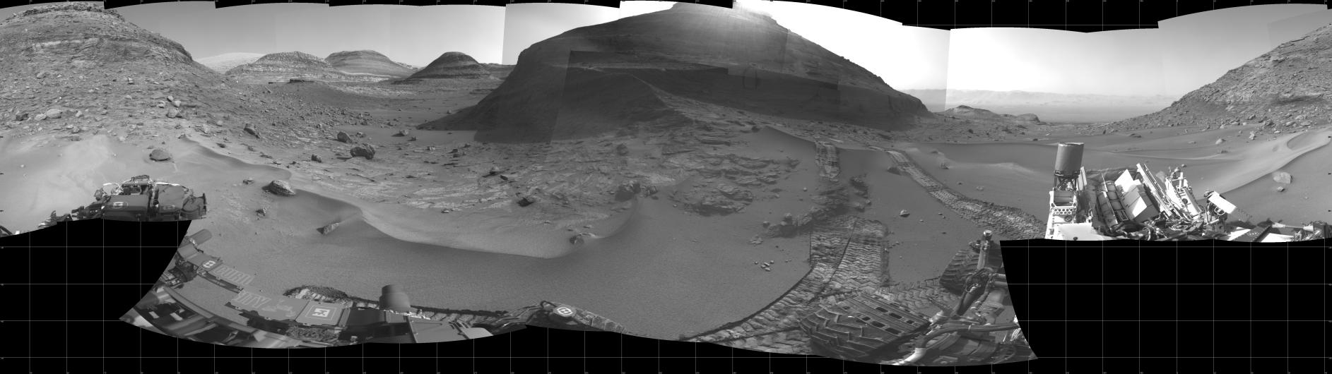
MarsPano

Listen to NASA’s Ingenuity Mars Helicopter in Flight
Mars Sounds

Psychological impact of false accusations of sexual abuse Some sort of satellite breaking apart and entering the atmosphere. Spotted Santa Monica Beaach
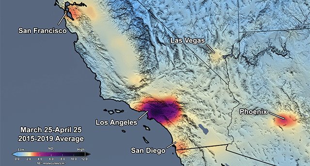
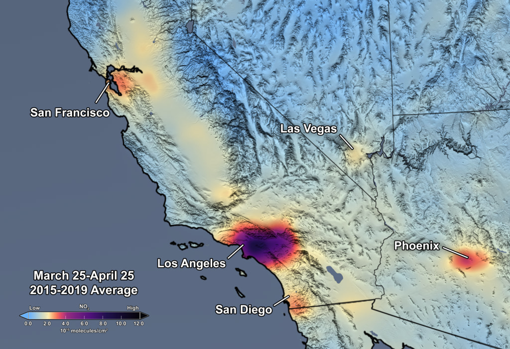
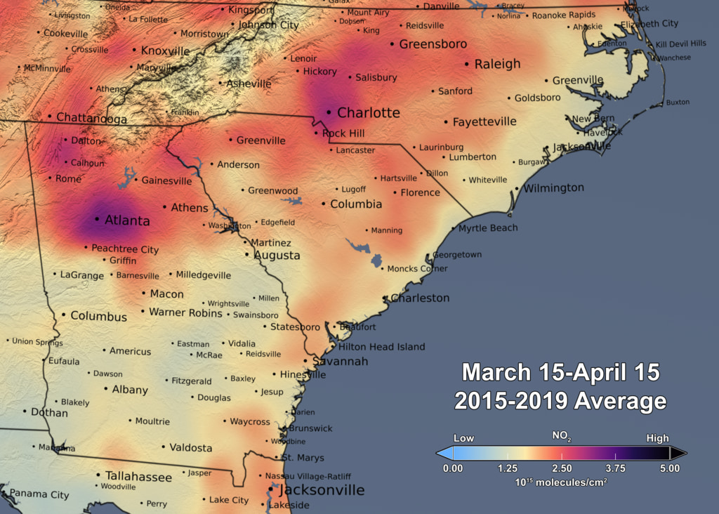
Nitrogen Dioxide over the Continental US and Los Angeles
Upon zooming into Southern California, finer details of pollution gradients are clearly visible over the Los Angeles/San Diego region. Here the concentration of NO2 is shown in shades of light blue to dark pink/purple indicating values ranging from low to high by CindyStarr Global Nitrogen Dioxide Monitoring Home Page @nasa @nasa-jpl @blackgirlscode @normani hi
Reductions in Pollution Associated with Decreased Fossil Fuel Use Resulting from COVID-19 Mitigation
Released Friday, April 24, 2020
Written by: Bryan Duncan Over the past several weeks, the United States has seen significant reductions in air pollution over its major metropolitan areas. Similar reductions in air pollution have been observed in other regions of the world. READMORE Released Friday, April 24, 2020


GRACE and GRACE-FO track California’s land water changes
NASA’s Gravity Recovery and Climate Experiment (GRACE, 2002 - 2017) mission, and its successor GRACE Follow-On (launched in 2018), map month-to-month changes in Earth’s gravity field resulting from the movement of mass, such as water, near the surface of the planet. This animation shows how the total amount of water (snow, surface water, soil moisture, and groundwater) varies in space and time, with the passage of dry seasons and wet seasons as well as with flooding, drought, and transport due to water management. Blue colors represent wetter than average conditions (relative to 2004-2010), while red colors represent drier than average conditions. The yellow line in the graph on the left shows the evolution of the long-term inter-annual variations for the area outlined in yellow on the map (note: the average seasonal cycle has been removed).
The Sacramento and San Joaquin River basins are outlined in yellow, and rivers and tributaries are shown as blue lines. The basins include California’s Central Valley, the most productive agricultural region in the U.S. Repeated drought conditions and increased water use in California have led to a long-term decline of terrestrial water, interspersed with above-average precipitation periods (e.g., 2015/2016, 2022/2023) that have allowed some recovery of the land water storage.
Credit NASA / JPL
Science On a Sphere: 4 Years of Biosphere
RelatedTweet
By monitoring the color of reflected light via satellite, scientists can determine how successfully plant life is photosynthesizing. A measurement of photosynthesis is essentially a measurement of successful growth, and growth means successful use of ambient carbon. This data visualization represents four years’ worth of data taken primarily by Suomi NPP/VIIRS satellite sensors, showing the abundance of life both on land and in the seaREADMORE


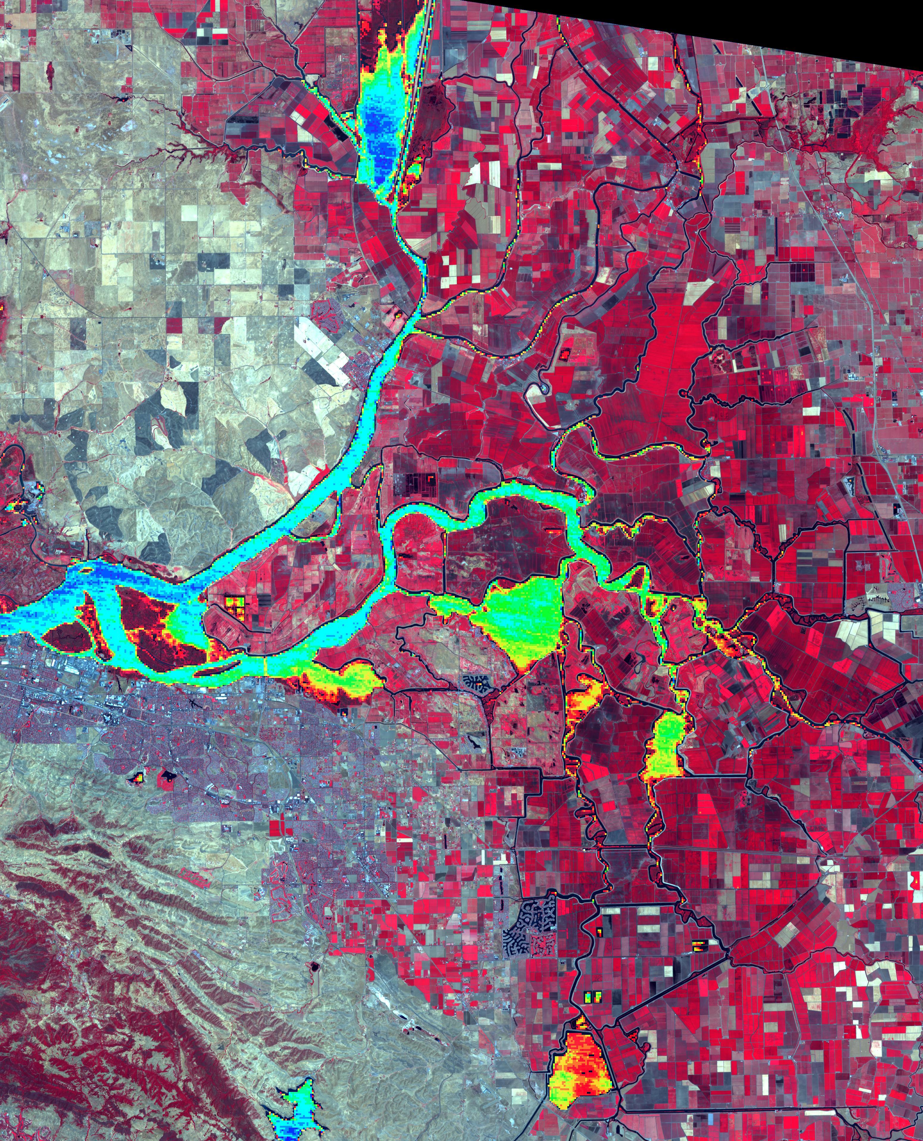
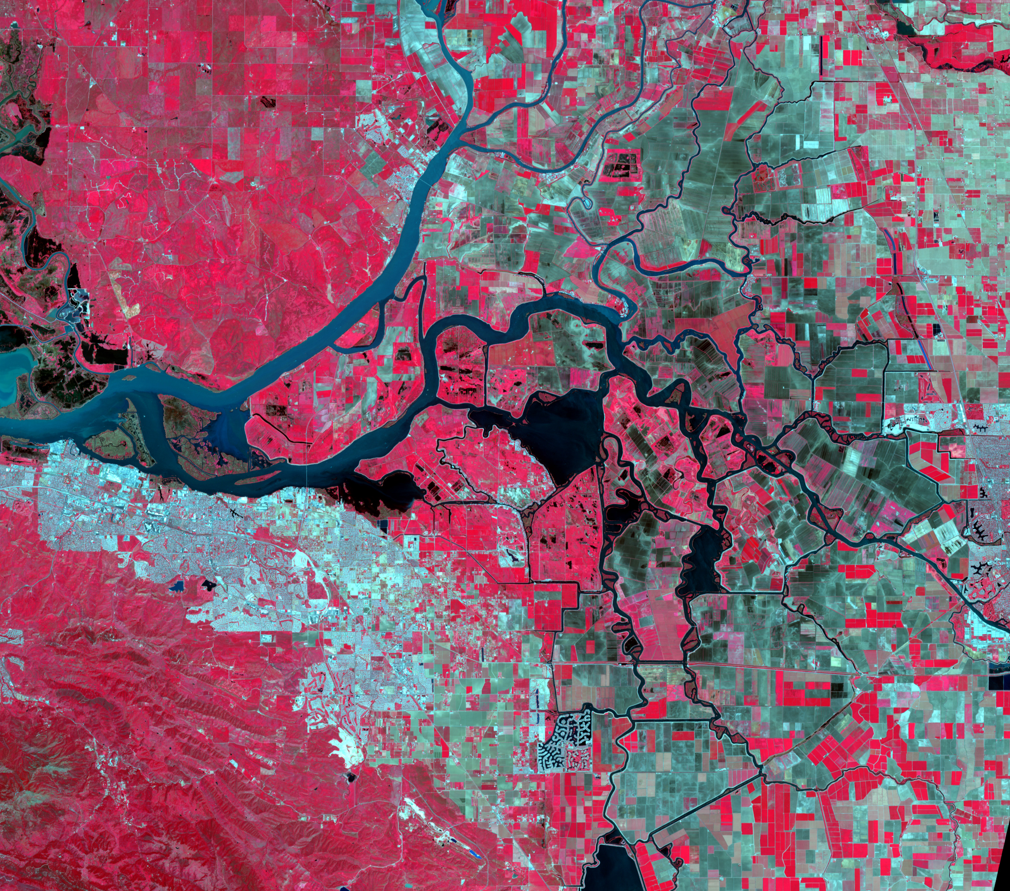
Levee Break Floods Central California
SEX TRAFFICKING IN ATLANTA GEORGIA❗️I ALMOST GOT KIDNAPPED❗️(story time😱🤬)ROSE POCAHONTAS @nasa @blackgirlscode @nasa-jpl @whitehouse


OutKast - ATLiens [FLAC 24 Bits]

National Water Information System: Mapper

Time Averaged Map of Irrigated water rate daily 0.125 deg. [NCA-LDAS Model NCALDAS_NOAH0125_D v2.0] kg m-2 s-1
over 1979-01-02 00:00:00Z - 2017-01-01 00:00:00Z


DOE Explains…Atmospheric Rivers
Biological and Environmental Research What are atmospheric rivers?

![]() ECOSTRESS - LOOK_AT_DATA_ACCUiSiTiON
ECOSTRESS - LOOK_AT_DATA_ACCUiSiTiON task

Panoply netCDF, HDF and GRIB Data Viewer

panoply \PAN-uh-plee\, noun: 1. A splendid or impressive array. …
Panoply plots geo-referenced and other arrays from netCDF, HDF, GRIB, and other datasets.
Panoply is a cross-platform application that runs on Macintosh, Windows, Linux and other desktop computers. Panoply requires that your computer has have had a compatible Java 11 (or later version) JRE or JDK installed. @blackgirlscode this looks cool like HiView Hi view is a camera on my primary mission Mars Reconnaissance Orbiter HiViEW-INSTRUCTiONS DOWNLOAD - HiViEW HiView is the best way to explore HiRISE images of the Martian surface at the full resolution of the imagery. Tracks of boulders that have fallen down crater walls, delicate rays of ejecta from fresh impact craters, and the unearthly formations created by carbon dioxide ice on the Martian south pole are just a few of the things that are waiting to be discovered by anyone using a tool like HiView with HiRISE imagery.
 By @NASA - http://photojournal.jpl.nasa.gov/catalog/PIA07087, Public Domain, Link

A quick tour of netCDF data - Argis
### Mars MissionObjectives MArs Reconnocinse Orbiter
![]()
 [https://github.com/ricoThaka/legacy-mars-global-climate-model]
gfortran — the GNU Fortran compiler, part of GCC Gfortran is the name of the GNU Fortran project, developing a free Fortran 95/2003/2008/2018 compiler for GCC
!
! Welcome to GDB Online.
! GDB online is an online compiler and debugger tool for C, C++, Python, Java, PHP, Ruby, Perl,
! C#, OCaml, VB, Swift, Pascal, Fortran, Haskell, Objective-C, Assembly, HTML, CSS, JS, SQLite, Prolog.
! Code, Compile, Run and Debug online from anywhere in world.
!
!

Program Hello
!Print *, "Hello World

!End Program Hello

!program hello
  ! This is a comment line; it is ignored by the compiler
  print *, 'Hello, World!'
end program Hello

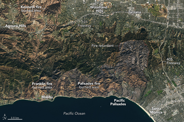
LoS Angeles Fires 2025


Now Orbiting MArs RelatedTweet elNino - Nasa Worldview 2024 DEC 01 To 2025 JAN 06
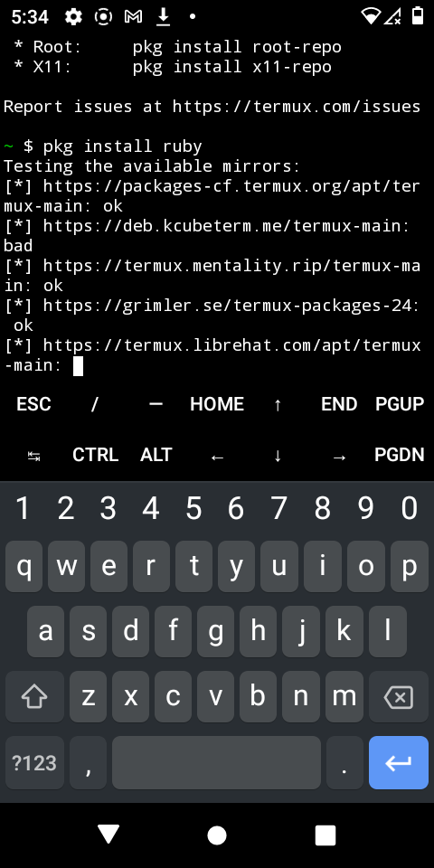
Termux-setup-storage
In order to have access to shared storage (/sdcard or /storage/emulated/0), Termux needs a storage access permission. It is not granted by default and is not requested on application startup since it is not necessary for normal application functioning. - wiki.termux.com


January 14, 2025
The Palisades Fire’s Footprint


![]()
NASA Maps California Drought Effects on Sierra Trees

Rhythm Roulette: 9th Wonder | Mass Appeal
https://earthobservatory.nasa.gov/images/event/153817/los-angeles-fires-2025 Eaton Fire Leaves California Landscape Charred 10 Best Data Import Tools for GIS Applications to Unlock Spatial Data - READLATER

.png)


 Related Metro

Related
Cryosphere
JPL - DisCOVrEpiC


Europa Clipper @nasa-jpl

Data collected from Mariner 4’s flyby on a modern map


![]()


Thankfully, the laboratory remains untouched by fire due to the brave dedication of our first responders. But our community has been seriously impacted with over 150 JPLers who have lost their homes and many more remain displaced.
— NASA JPL (@NASAJPL) January 12, 2025


telstar
AT&T Archives: Telstar! Building Telephone Lines in the desert 1929 Telstar 1
RelatedTweet info - airandspace.com Bell Labs - TelStar NASA
AT&T Archives: A Modern Aladdin’s Lamp, about vacuum tubes,1940


Liquid soil moisture content (0-10cm) monthly 0.125 deg. [NLDAS Model NLDAS_NOAH0125_M v2.0] kg m-2
- Selected date range was 2000-Jan - 2024-Dec. Title reflects the date range of the granules that went into making this result. @nasa-jpl @blackgirlscode plots by -#rashard giovanni Search


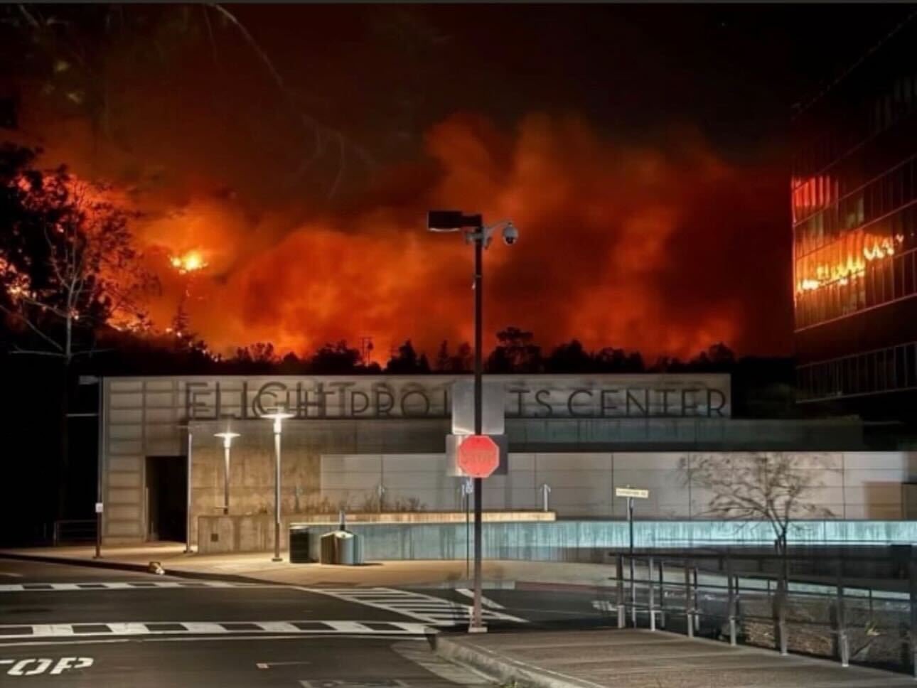


Fires Tear Through Los Angeles - VisibLEEarth RelatedTweet


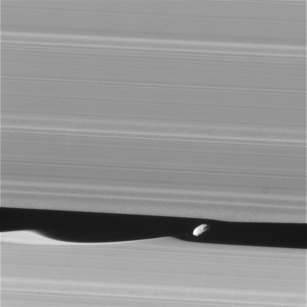 Daphnis


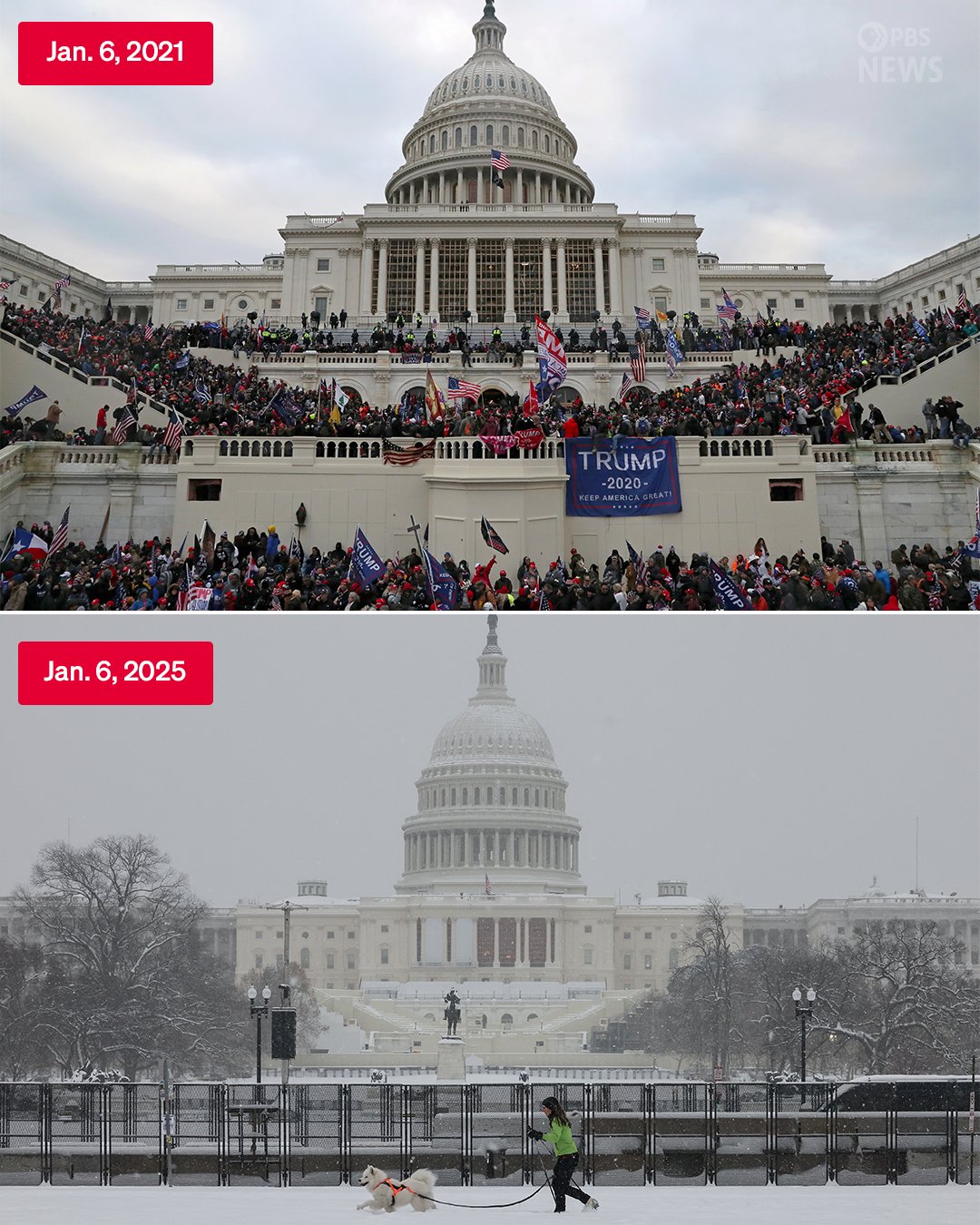
President Biden’s Farewell
Remarks by President Biden in a Farewell Address to the Nation - @whitehouse @nasa-jpl NYTimES - Transcript
Rashard Kelly NasaJpl MRO JUNO iSS


i did it for jehovah, now i do it for the world-casualDaily atm!


Thank You for science MrCarter💯❤️🔥❤️🩹💯🥺💔 @whitehouse @nasa-jpl thanks for caring for my family with science tools. I use so much u provide to teach and share independance
All Night Long : by Common Feat EryKah Badu

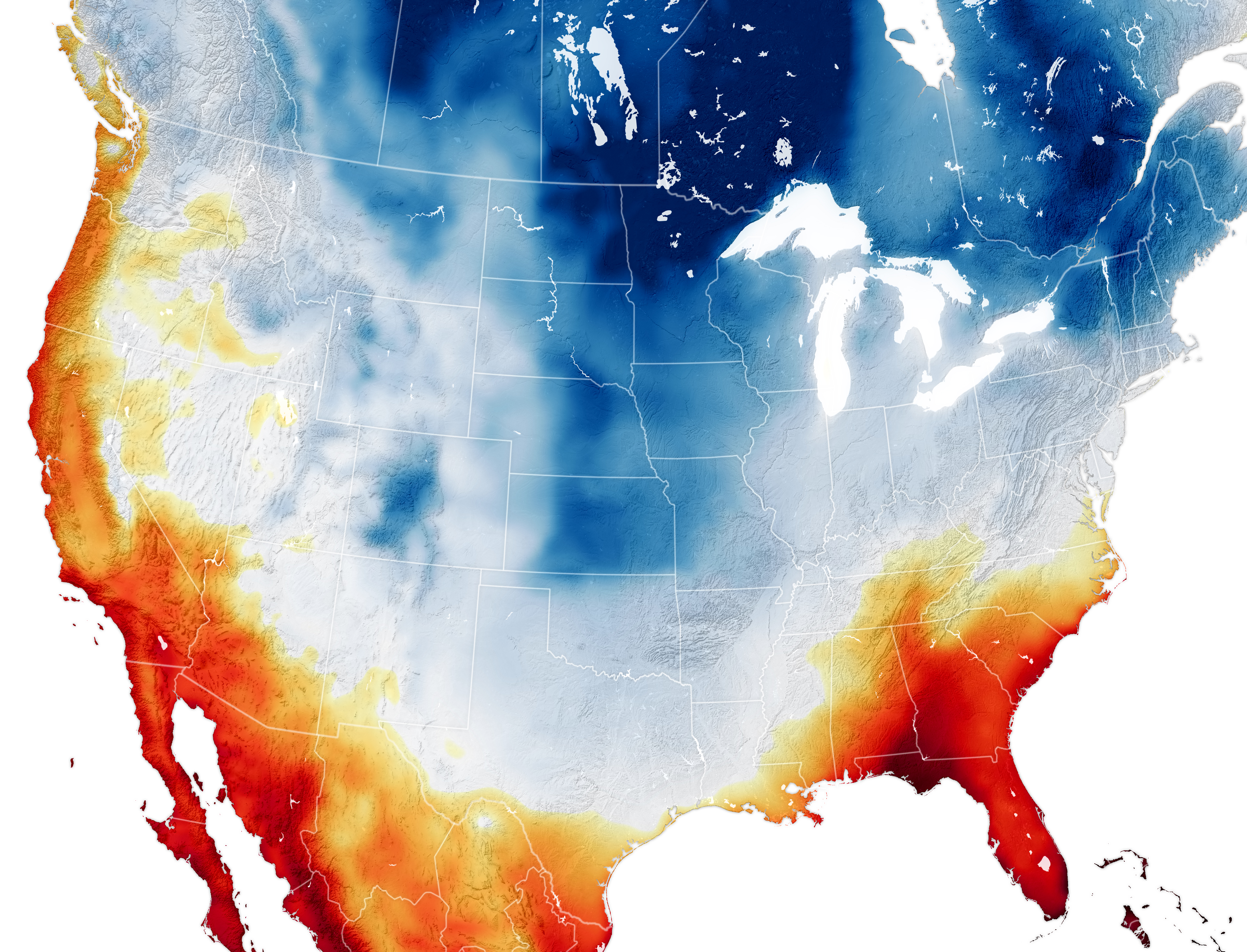
Cold and Snow Wallop the U.S.
The first major, widespread winter storm of 2025 delivered snow, ice, and frigid temperatures to a large swath of the country.ReadMore - Nasa_EarthObservatory Tools`>AquaModis OCEANCOLOR
The “IT” GIRLS 💗💅🏽| A Kinigra Deon Original
book with same title LightboxViewer Kinigra Deon Kinigra TiKTOK KinigRa on @twitter @nasa-jpl this is one of the girls from atlanta(ish) that need protection digitally @blackgirlscode she made a movie an she know coral~


- +2TUPPERWARELATER - Explore data from ESA’s Solar System missions
- 4rashardmro - W3.CSS Navigation Tabs find sega sonic promosite window refnews TrumpPhotos onashardMRO
Wifi IEEE 802.11b-1999


CLimatology


RoSe Pocahantas


The Transistor: a 1953 documentary, anticipating its coming impact on technology FREAKNiK on HULU @nasa GoogleEARTUh
 Scientific Visualization Studio
webtools
DSCOVR: EPIC
Earth
## NASA DsN
#theSUN() resources
Johs Hopkins APL
the STEREO website
SDOlab
TheSun
DEEP SPACE NETWORK
![]() waybackmachine
The real time status of communications with our deep space explorers
GEOCiTiS
waybackmachine
The real time status of communications with our deep space explorers
GEOCiTiS
EarthData Search
EarthData Search DAR Tool @usgs
ASTER Mission
Advanced Spaceborne Thermal Emission and Reflection Radiometer
 ASTER is a cooperative effort between NASA and Japan’s Ministry of Economy Trade and Industry (METI), with the collaboration of scientific and industry organizations in both countries. The ASTER instrument provides the next generation in remote sensing imaging capabilities when compared to the older Landsat Thematic Mapper and Japan’s JERS-1 OPS scanner. ASTER captures high spatial resolution data in 14 bands, from the visible to the thermal infrared wavelengths, and provides stereo viewing capability for digital elevation model creation.
The Advanced Spaceborne Thermal Emission and Reflection Radiometer MADAS @nasa-jpl @usgs Natural Disaster from Space MAP - ASTER
ASTER is a cooperative effort between NASA and Japan’s Ministry of Economy Trade and Industry (METI), with the collaboration of scientific and industry organizations in both countries. The ASTER instrument provides the next generation in remote sensing imaging capabilities when compared to the older Landsat Thematic Mapper and Japan’s JERS-1 OPS scanner. ASTER captures high spatial resolution data in 14 bands, from the visible to the thermal infrared wavelengths, and provides stereo viewing capability for digital elevation model creation.
The Advanced Spaceborne Thermal Emission and Reflection Radiometer MADAS @nasa-jpl @usgs Natural Disaster from Space MAP - ASTER
![]()
Fire Information for Resource Management System FiRMS
NASA | LANCE | FIRMS - NASA Firms
TELNET COMMANDS - ulTRAX’S ARCHIVE TELNET - LIST OF TELNET SERVERS - Places to Telnet Places to Telnet - TELNET.ORG TELNETDiR - https://victoria.tc.ca/history/internet/telnet-sites.html - BLOCKED at LAPL What are your favorite Telnet sites (Besides Fozz’s) - REDDiT r/retrobattlestations/
GO-5Y7R5 - the globe program
forums
EarthData 12ozProphet graffhelp


 KI & KI2 in MAME v140 - Pre-configured MAME 7-Zip Package Instructions


older posts
